

The Earth’s surface is continually changing as tectonic plates stretch apart, collide and slide past each other. Satellite radars are transforming the way we monitor our dynamic planet, helping us to predict future volcanic eruptions and understand the distribution of earthquake hazard.
I lead the UK Natural Environment Research Council’s Centre for the Observation and Modelling of Earthquakes, Volcanoes and Tectonics (COMET). Our research aims to improve our understanding of earthquakes and volcanic eruptions. We want to know what causes them, and we want to be able to provide better estimates of the likelihood of these natural disasters occurring.
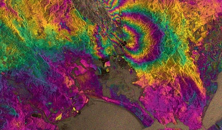
Earth observation satellites have transformed the way we work. We use them to measure how the ground deforms around earthquake faults and volcanoes. These very precise measurements of ground motion enable us to build geophysical models of the processes occurring beneath the Earth’s surface, and to estimate hazard. So, how can satellites orbiting 800 km above the Earth measure ground motions as small as 1 mm? The method we use, Interferometric Synthetic Aperture Radar (InSAR), relies on radar satellites in very precisely controlled and well-known orbits. These satellites can come back to the same area every few days, each time sending radar waves down to the ground surface and measuring the energy that is reflected back. By analysing the images from different satellite overpasses, we can measure precise differences in the time it takes the radar pulses to make the round trip from the satellite to the Earth and back. If part of the ground in the radar image has moved further away from the satellite since its last overpass, perhaps because of an earthquake or volcanic eruption, the radar waves will take slightly longer to return to the satellite. We can measure these differences, or path delays, in every pixel of the radar image to give us a map of how the ground has moved, with accuracy of a few millimetres.
InSAR is particularly important in remote areas and developing countries because it does not rely on having expensive instruments on the ground. Even in places like California and Japan, where there are extensive networks of ground-based instruments, no other technique can give us measurements with InSAR’s spatial resolution (tens of metres) covering such large areas (tens to hundreds of kilometres). After earthquakes, for example, it is often the radar images that lead geologists on the ground directly to the fault that caused the earthquake. In some parts of the world, this can be tens of kilometres away from seismologists’ estimates of the location of the earthquake epicentre. We can also use the radar to identify areas that have been damaged, providing vital information for emergency response teams.
Predicting future eruptions
As well as measuring the deformation after a catastrophic event, InSAR can help us to understand where and when future disasters might occur. For example, before many volcanic eruptions, the magma rises up into a shallow reservoir beneath the volcano. This causes the surface around the volcano to lift up, much in the same way as a mattress would bulge if you pumped up a balloon underneath it. We are now beginning to systematically monitor all active volcanoes for signs of magma movement. The goal is to use this information to alert local decision-makers and scientists that a particular volcano is showing signs of activity. Decisions can then be made, such as whether to put more ground-based monitoring instruments in place or, ultimately, to evacuate.
Although giving short-term predictions for earthquakes is most likely impossible, the ground surface around faults also steadily warps in response to tectonic forces during the long periods between earthquakes. We can use InSAR to measure this warping, and to assess and forecast the risk of earthquakes in a particular location. Conventionally, hazard estimates are based on the earthquakes that have occurred over the last 100 years, for which we have good seismic records. In some places, historical records of earthquakes are also used to look further back in time. However, many earthquake faults only fail once every 10,000 years or more, so estimates of seismic hazard based on even the last 1,000 years are not reliable. By measuring the warping around earthquake faults using InSAR, we can identify active faults at risk of earthquakes, even if they haven’t been known to fail before.
The launch of Sentinel-1A in April 2014 was a pivotal moment in the history of InSAR. Previous satellite radar missions were not designed or optimised for InSAR, having long orbital repeat times, poor orbital control, no clear strategy for acquiring data and, in some cases, charging large fees to purchase the data. All of this prevented widespread uptake of the technology. By comparison, Sentinel-1A is the first of a constellation of two satellites, with 1B joining it in orbit in 2016. Together, the two satellites will acquire data frequently and systematically over all the tectonically and volcanically active areas of the planet. The data will be freely available to the whole Earth observation community, and the mission has a long duration, with future satellite launches planned to extend data collection to at least 20 years. It is truly the first operational InSAR satellite.
At COMET, we are building an automatic processing system to handle the vast quantities of radar data from Sentinel-1. Our main aim is to use the many thousands of images acquired each year from all of the Earth’s tectonic zones to map ground deformation with extraordinary accuracy, making a quantifiable difference to estimates of seismic hazard. To do this, we will need to detect tectonic strains caused by movements as small as 1 mm per year between two points separated by 100 km. We will use this information to build a new seismic hazard map based on deformation observations, rather than on historical records of past earthquakes. As well as looking at average rates of motion, we will be looking for changes in the rates of motion which may, for example near volcanoes, suggest activity. The data will also help us understand more about the properties of the outer layer of the Earth, which will help to build better models of how the continents deform.
Building a system to handle the volume of data coming from Sentinel-1 is not straightforward. The raw data alone will fill up a typical laptop hard disk four times a day. We are using extensive cloud computational resources at the facility for Climate and Environmental Monitoring from Space (CEMS), which will be operating continuously to keep pace with new data acquisitions. The guaranteed availability of data should mean we can respond in near real time to any eruption or earthquake. We aim to provide information to the community via the web as quickly as possible so that it is useful both to scientists and emergency responders on the ground.
Further applications
There are a number of potential spin-offs from these technological developments. The main source of error in InSAR deformation measurements comes from the weather – water vapour in the atmosphere slows down the radar waves. Weather modellers are quite poor at predicting the precise spatial distribution of water vapour in the atmosphere, so we can use the noise in our data to map water vapour at high spatial resolution. We are now planning to work with the UK Met Office so that they can incorporate this information into future generations of their operational weather forecasting model.
The ground surface also deforms for many reasons that have nothing to do with plate motions or active volcanoes. For example, the results of our work with Sentinel-1 can be used to monitor how much the ground is subsiding due to mining or tunnelling below ground, or extracting water or gas. This is particularly relevant in the UK, where there is still a large amount of surface deformation as a result of past coal mining. Many governments around the world plan to store captured carbon underground in the future – InSAR can be used to monitor whether the captured CO2 stays where it was injected. We can also potentially use InSAR to monitor the stability of buildings or other critical infrastructure, such as bridges or railway lines.
Sentinel-1A has already provided valuable scientific results, such as helping us map the fault that caused an estimated $1 billion of damage to the wine industry in the Napa Valley of California in August 2014. This is just a taste of what is to come from this extraordinary mission. Although earthquakes cannot be predicted with 100 per cent accuracy, I can confidently say that the future for InSAR is extremely positive, and that this technology will transform our understanding of our dynamic planet over the next decade.