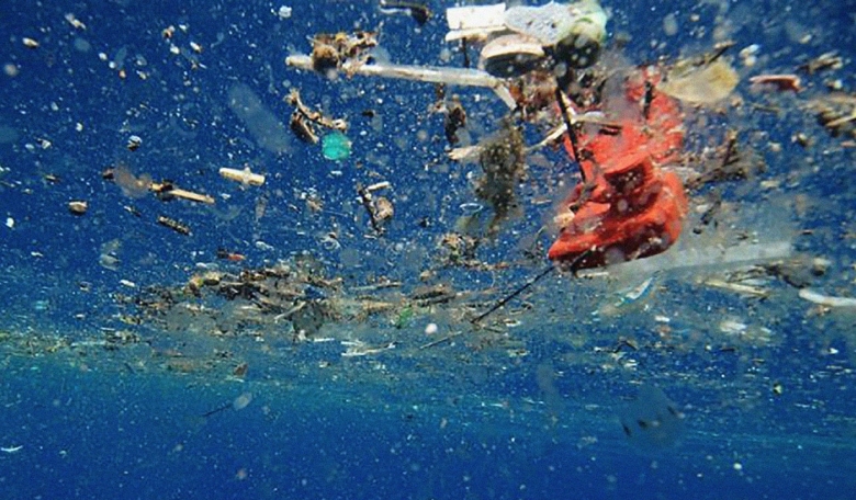
Marine litter presents a huge problem in our oceans with some scientists warning that by 2050 the quantity of plastics will outweigh fish. Omnipresent plastic materials of all shapes and sizes break down very slowly in the marine environment; estimates suggest more than 400 years in many cases. They originate from many sources and cause a wide spectrum of environmental, economic, safety, health and cultural issues, as well as being harmful to marine life. ESA is now pioneering studies to find out if satellite monitoring could provide crucial data to support solutions towards cleaner seas.
Marine litter (ML) can be defined as any item that has been made or used by people that ends up deliberately or accidentally in the sea. The identification of the origin and pathways that lead to litter entering the marine environment can be very complex, due to the multitude of potential sources but also because it can be transported by sea currents and wind across long distances [1].
Plastic ML is a global issue and can be found in all seas from the equator to the poles, as well as in freshwater systems and, according to the United Nations, it causes an estimated US$13 billion of financial damage annually to marine ecosystems. Marine animals can be injured or killed as they become entangled in items such as derelict fishing nets, or ingest plastic that has been mistaken as food.
 Concentrations of plastic ML in surface waters of the global ocean predicted by numerical models. In the global map, dark and light grey areas represent inner and outer accumulation zones, respectively. Darker areas are predicted to have higher concentrations. The coloured circles indicate the measured numbers of plastic items per km2 from in-situ sampling, as per the legend.
ML imposes high annual costs to clean up the beaches from all the waste that is deposited by the sea to keep them attractive for tourism (in Belgium and Netherlands, for example, the total cost of ML removal from the beaches is estimated to be about €10 million/year), and there are also costs related to damage to fishery activities and vessels. The issue is also becoming a concern for human health due to contamination of seafood with plastic particles and associated pollutants, some of which are known to be harmful to humans.
According to monitoring data, the large majority of ML is plastics [2], in particular buoyant polymers - polyethylene (PE), polypropylene (PP) and polystyrene (PS). In the last few decades, plastic ML has accumulated in the oceans and seas at a dramatic pace [3], [4], [5], [6], [7]. It has been estimated that between 4.8 and 12.7 million tonnes of plastic entered the ocean from land in 2010 alone [8], equating to a rough average of eight million tonnes per year without considering the constant increase in plastic production. Despite this large input, it is estimated that only about a quarter of a million tonnes is floating on the surface of the ocean [7], with most of the plastic likely sinking.
Plastics in the seas progressively fragment due to combined photodegradation by solar ultraviolet radiation, temperature variations and action of waves and marine life. As plastics break down, they also leach out chemical additives linked to environmental and health problems (e.g. Bisphenol A).
Those plastic items and pieces that are not recaptured by coastlines, or that do not lose buoyancy and consequently do not sink, are slowly transported by ocean dynamics into main areas of accumulation, in particular the gyres (areas of circulating currents) in the Pacific, Atlantic and Indian oceans. Recent estimates provide average concentrations of about 70 kg/km2 of plastics and of about 700,000 pieces/km2 in the Great Pacific Garbage Patch in the North Pacific gyre [9]. It takes centuries for plastic particles to completely disintegrate.
ML is addressed by a European Directive - the Marine Strategy Framework Directive (MSFD - 2008/56/EC), which requires European Union (EU)Member States to monitor the problem and ensure that “properties and quantities of marine litter do not cause harm to the coastal and marine environment”.
Among the conclusions of the G7 Ministers of Science Meeting in Berlin in October 2015, ML, and in particular plastic ML, was addressed as a threat to marine life and habitats as well as presenting health and safety concerns for humans.
The International Association for the Physical Sciences of the Oceans (IAPSO) and the Scientific Committee on Oceanic Research (SCOR) published a joint report with recommendations for actions to the issues identified at the G7 meeting.
The section ‘Plastic pollution of the marine environment’ concluded that “research needs and G7 actions include appropriate sensors on satellites, autonomous aircraft and in-situ observing systems, capable of monitoring larger items of floating litter as well as concentrations of smaller items”.
 Mass concentrations of plastic litter in surface waters of the Mediterranean. The grey-scale base map in the Mediterranean basin shows the relative surface plastic concentrations predicted by numerical modelling. Darker areas are predicted to have higher concentrations. The coloured circles indicate average mass concentrations from in-situ sampling.
Data collection
Plastic marine litter is not a natural phenomenon but is an anthropogenic issue we need to solve
Existing ground-based data collection systems are limited and unable to answer fundamental questions such as concentrations of ML and spatial and temporal dynamics, mainly due to the vastness of the problem, diversity of the types of ML and its general sparseness. The majority of the data gathered so far comes from collecting ML items along coastal monitoring sites and from rare expeditions with boats, mainly in the subtropical gyres of the northern hemisphere.
There is little or no data from the higher latitudes in the northern hemisphere, in the southern hemisphere and in the equatorial regions. Data are also very limited for the coastal oceans, which are important because they are extremely productive biologically and are more directly connected with human activity.
These data are necessary in order to calculate the global ML mass budget and concentrations, and to support and validate predictive computer models. If a remote sensing system could provide these data on a large scale, possibly at global level, it would have a drastic impact, not only from a scientific viewpoint but also to provide tools for environmental monitoring and for assessing the efficacy of the efforts of policymakers in addressing the ML issue.
Remote sensing of marine litter
The remote sensing of ML is in its infancy and there is no doubt it represents a big technological challenge [11]. The first applications of remote sensing to detect ML focused on large items such as fishing nets, buoys and large ropes [12].
The Ghost Net Project, for example, tried to merge data from airborne and satellite sensors to spot large fishing nets lost at sea, the so called ‘ghost nets’ [13]. Ghost nets seem to represent a very large fraction of the mass of global ML and in particular they are considered the main contributor to the total mass of the plastic ML in the Great Pacific Garbage Patch [9].
Although several potential detection technologies already exist, many of them have not been systematically applied to ML detection. The main remote sensing technologies that could potentially be used to detect ML are described briefly below.
High resolution panchromatic imaging
This technique uses high resolution pictures taken with photographic cameras. High resolution cameras have been used to identify metre-sized ML mainly from aircraft but also from satellites. The technique has been used to identify large ML items that drifted from Japan to the American continent following the disaster caused by the tsunami in Japan in March 2011 that generated 1.5 million tonnes of floating debris.
The key requirement for this technique is spatial resolution and the best resolution achievable by non-military satellite is currently 25-30 cm. This limits the application of the technology to ML items with a size on the same order of magnitude for detection, or larger for specific identification. Image processing techniques are then applied to detect anomalies in the scene, also exploiting colour-aided contrast techniques. An approach based on high resolution imaging offers the best chances to detect and identify large ML items, which account for the majority of the mass of plastic ML.
On the other hand, it requires an active interpretation of a huge amount of high resolution images in order to identify the ML items in the oceans, and a capability to filter false alarms caused by foam, white caps and other floating organic objects such as algae and large animals.
Finally, this technique does not allow the detection of the presence of concentrations of small litter items and pieces, in particular so-called microplastics (items and pieces smaller than 5 mm). Although microplastics account for only a fraction of the mass of plastic ML, it represents by far the highest fraction in terms of number of pieces, making it the most frequent type of litter encountered in the oceans and seas.
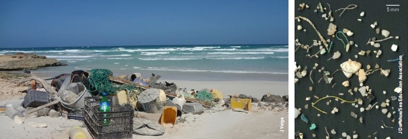 Microplastics (above) collected in the North Pacific subtropical gyre and (left) large ML items, mainly plastics, stranded on a secluded beach.
Optical spectro-radiometric techniques
These allow measurements of the spectral power distribution of a particular scene or, in other words, how the light is reflected (and emitted as in the case of the thermal infrared) from the surface of the water across the spectrum the sensor is sensitive to.
Passive sensors can acquire reflected solar light (and emitted light) in the visible and infrared spectrum, while active sensors acquire the backscattered light generated by an onboard laser - generally called a LIDAR (LIght Detection and Ranging).
Some of these sensors can offer the capability to resolve the signal received with high spectral resolution (hyperspectral sensors), allowing the detailed acquisition of specific spectral features of the ML items.
For the relatively low concentrations of ML in the oceans, the signal might be extremely low and potentially degraded by the atmosphere sufficiently to pass undetected by current orbiting sensors. As a consequence, a trade-off is necessary: while a high spectral resolution has the advantage of allowing a more accurate identification of the nature of the ML, it negatively affects the signal strength. Similarly, the higher the spatial resolution (i.e. smaller the acquired scene) the lower the signal strength, because in both cases the acquired amount of light is lower.
The great advantage of these techniques is the possibility to spectrally identify the nature of the anomaly detected in water, whether it is plastic or not, possibly even which kind of plastic, and to provide a rough quantification of it, on the basis of the signal strength received.
There is little or no data from the higher latitudes in the northern hemisphere, in the southern hemisphere and in the equatorial regions
A limiting factor is that the most significant spectral features of plastics are in the Short Wave Infra-Red (SWIR), roughly between 1000 nm and 2000 nm, and at these wavelengths the light is practically fully absorbed by the water.
This means that all the plastics floating sub-surface (typically in the first few metres under the surface) cannot be detected by SWIR sensors. On the other hand this can be an advantage for the ML floating on the surface because the surrounding water, especially the clear water of the oceanic gyres, does not reflect any SWIR signal consequently representing a low-noise background. Nevertheless, the aged plastic ML items floating on the surface are likely to be covered by a thin film of water, which degrades the signal strength.
Another limitation to spectro-radiometric techniques is the fact that, in time, plastic ML at sea accumulates bio-fouling (a layer of microorganisms, plants, algae, animals) on the surface, which could mask the material underneath, preventing detection of the ML item.
Finally, among the LIDAR techniques, particularly promising techniques could be based on Fluorescence and Raman spectroscopy, although the latter operates with a signal relatively too weak to be realistically applicable for satellite monitoring.
Microwave-based technologies
The focus here is on radar (RAdio Detection And Ranging) techniques, a technology based on the active emission of microwaves (currently in the range 1-35 GHz, considering operational devices and demonstrators) and detection of the backscattered signal. Current payloads can generate radar images with a spatial resolution of up to about one metre. Materials can be also identified by the intensity and polarimetric features of the detected signal. In the lower frequency range, radar operations are unaffected by cloud cover and rain. Radar has already been used to provide information on parameters of the ocean surface including topography, roughness, surface waves, and in particular winds and currents, consequently representing an important technique to locate potential sites of ML accumulation. As of today, radar, and in particular Synthetic Aperture Radar (SAR), has the potential to detect and track floating ML items roughly meter-sized or larger, for example ghost nets.
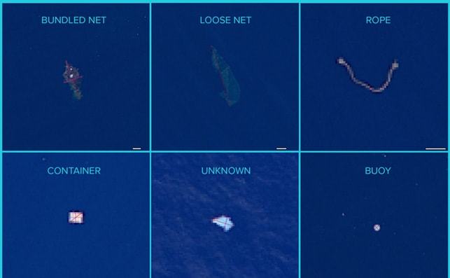 Aerial images of large ML items taken by a high resolution camera over the Great Pacific Garbage Patch.
European Space Agency studies
Remote sensing of marine litter is in its infancy and there is no doubt it represents a big technological challenge
Under the General Studies Programme (GSP), the European Space Agency (ESA) initiated in 2017 the project ‘Remote Sensing of Marine Litter’ by funding two parallel contracts - RESMALI, led by Argans Limited, UK (team including: the University of Cadiz, Airbus and The Ocean Cleanup) and OPTIMAL, led by the Plymouth Marine Laboratory, UK.
The project has two main objectives: 1) to define the most important applications and the preliminary mission requirements for the remote sensing of plastic ML, and 2) to perform experimental and modelling activities in order to identify the minimum detectability limit of plastic ML from orbiting sensors.
In support of the first project objective, the GSP office funded the organisation of the first workshop on ‘Remote Sensing of Marine Litter’ in ESA-ESTEC, Noordwijk, The Netherlands, in November 2017, with the participation of about 20 international experts in the fields of ML and remote sensing.
The workshop provided recommendations on the most important applications, mission requirements and potential candidate technologies. In addition, it promoted the establishment of a cooperating community which has already started a series of joint initiatives.
A paper with the most important conclusions on the preliminary mission requirements and other project outputs will be released soon. Some of these conclusions have been presented at the 6th International Marine Debris Conference in San Diego, USA, in March 2018.
The ESA projects are focusing on investigating passive optical spectro-radiometric remote sensing. As explained above, the basic idea is to have a sensor that collects the solar light, at different wavelengths, reflected by the plastic items and pieces (independently of their size) floating in the sea.
This is a global issue and cooperation and information sharing are essential
ESA teams are currently performing a test campaign to characterise plastic marine litter, both in dry and wet conditions, in terms of optical reflectance properties in the visible and infrared light spectrum, namely in the range 400-2500 nm, where plastics present spectral features that should help in detecting and possibly quantifying them. These spectral signals are acquired for different concentrations and kinds of plastics in different degradation states.
Some of the plastic samples used were collected in the Pacific and Atlantic garbage patches and frozen immediately afterwards to preserve the biofilm that had formed on their surface over the years. The test results (reflectance measurements) will be transferred to computer models that can process how the signals will be degraded by the atmosphere. This will indicate, to a first approximation, if measuring plastic ML with the available technologies from space is feasible. It will also show up to which ML concentrations, or at which height in the atmosphere this could be possible (by consequently using planes or drones), or what improvements are necessary in the current technology to achieve this goal.
Although none of the currently orbiting instruments were designed to detect plastic ML, ESA teams are also exploring the monitoring capabilities of existing satellites, including the ESA Sentinels. They will try to extract information from satellite images of areas where it is possible to measure, at the same time, the presence of plastic ML with airborne and ground equipment.
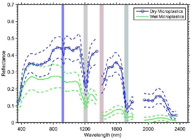 Spectral reflectance from the visible to the SWIR of dry and wet marine-harvested microplastics; the shaded regions indicate the main absorption features of plastics.
Why monitoring marine litter is important
Plastic ML is not a natural phenomenon but is an anthropogenic issue we need to solve. This can be done either by prevention, that is by avoiding plastic waste reaching the seas, or by remediation, by removing the plastic litter that is already in the seas.
Remote sensing of ML has not only the potential to provide monitoring on a global scale and to support and validate predictive models but could also contribute to the prevention and remediation of the issue in the following ways:
- by providing clear data for policy-makers to take measures against the increasing production of plastic marine litter and by monitoring the effectiveness of these measures
- by pinpointing the major sources of litter (monitoring coastal waters, estuaries and large rivers)
- by guiding potential cleaning missions and assess their efficiency.
Ultimately a global concentration map of plastic marine litter will very likely come not from a single sensing solution but from the data fusion of a large network of different remote sensors on different platforms (satellites, planes, drones and boats) and in-situ observations (on boats and beaches), together with a supporting knowledge of the general conditions of the sea surface with respect to wind, waves and swell. It is consequently important to interact with a large international community of scentists and experts. This is a global issue and cooperation and information sharing are essential.
About the authors
Paolo Corradi has been working with ESA at ESTEC since 2009, first as payload system engineer for the International Space Station and currently as optical system engineer in the Optics Section, Mechatronics and Optics Division. He has a master’s degree in electronic engineering from the University of Parma, Italy, and a PhD in microsystems engineering from the University of Roma Tor Vergata, Italy.
José Gavira Izquierdo leads the Mechatronics and Optics Division at ESA that oversees and coordinates R&D of Optics and optoelectronics technologies for all ESA applications in Earth observations. He has over 33 years’ experience in space activities, holding a master’s degree in Space System Engineering from Delft university and in Mechanical Engineering from the Polytechnic University of Madrid.
Ian Carnelli is an aerospace engineer managing the General Studies Programme, charged with the preparation of future ESA activities. Its main focus is support to the definition of future missions and interdisciplinary research for the development of enabling technologies. Since 2015 he has led teams of scientists and engineers working on deep-space probes to deflect potentially threatening asteroids.
Luca Maresi has more than 25 years of experience in the design and manufacture of optical instruments for space. His many space projects have included the Cassini probe to Saturn and he is currently Head of the Optics Section, at ESA’s ESTEC where he is responsible for a number of R&D projects in the field of optical technology, materials and components.
References
1 J.M. Veiga, D. Fleet, S. Kinsey, P. Nilsson, T. Vlachogianni, S. Werner, F. Galgani, R.C. Thompson, J. Dagevos, J. Gago, P. Sobral, and R. Cronin, “Identifying Sources of Marine Litter” MSFD GES TG Marine Litter Thematic Report 2016, JRC Technical Report; EUR 28309 ; doi:10.2788/018068
2 OSPAR-Commission (2010a) “Quality Status Report 2010”, OSPAR Commission, London, 176 pp.
3 D.K.A Barnes, F. Galgani, R.C.Thompson, M. Barlaz, “Accumulation and fragmentation of plastic debris in global environments” Phil. Trans. R. Soc. B 2009 364 1985-1998.
4 K.L. Law, S. E. Morét-Ferguson, N. A. Maximenko, G. Proskurowski, E. E. Peacock, J. Hafner, et al. “Plastic accumulation in the North Atlantic Subtropical Gyre”. Science 2010; 329: 1185-1188.
5 A. Cózar, F. Echevarría, J.I. González-Gordillo, X. Irigoien, B. Úbeda, S. Hernández-León, et al. “Plastic de- bris in the open ocean”. Proc Nat Acad Sci. 2014; 111(28): 10239-10244.
6 A. Cózar A, M. Sanz-Martín, E. Martí, J.I. González-Gordillo, B. Ubeda, J. A. Gálvez, et al. “Plastic Accumulation in the Mediterranean Sea”. PLoS ONE 10(4):e0121762, 2015.
7 M. Eriksen, L. Lebreton, H. S. Carson, M. Thiel, C. J. Moore, J. C. Borrero, et al. “Plastic Pollution in the World’s Oceans: More than 5 Trillion Plastic Pieces Weighing over 250,000 Tons Afloat at Sea”. PLOS ONE. 2014; 9(12): e111913.
8 J. R. Jambeck et al. “Plastic waste inputs from land into the ocean”, Science, 2015, 347(6223), 768-771.
9 L. Lebreton et al. “Evidence that the Great Pacific Garbage Patch is rapidly accumulating plastic”, Nature Scientific Reports, 2018.
10 P. Williamson, D. Smythe-Wright, and P. Burkill, Eds. “Future of the Ocean and its Seas: a non-governmental scientific perspective on seven marine research issues of G7 interest”. ICSUIAPSO-IUGG-SCOR, 2016, Paris.
11 N. Maximenko et al. “Remote sensing of marine debris to study dynamics, balances and trends”, NASA Workshop on Mission Concepts for Marine Debris Sensing, 2016, University of Hawaii at Manoa, Hawaii.
12 T. H. Mace, “At-sea detection of marine debris: Overview of technologies, processes, issues, and options”, Marine Pollution Bulletin, Vol. 65, Issues 1-3, 2012, pag. 23-27.
13 W.G. Pichel, T. Veenstra, J. Churnside, E. Arabini, K.S.Friedman, D. Foley, R. Brainard, D. Kiefer, S. Ogle, and P. Clemente-Colon, “Ghost Net-Derelict net detection in the North Pacific and Alaska waters using satellite and airborne remote sensing and surface drifters”, Thirtieth International Symposium on Remote Sensing of the Environment, 2003, Honolulu, USA.
14 S. P. Garaba, H. M. Dierssen, “An airborne remote sensing case study of synthetic hydrocarbon detection using short wave infrared absorption features identified from marine-harvested macro- and microplastics”. Remote Sensing of Environment 205 (2018) 224-235.


