


In the first part of his overview of China’s satellite surveillance capabilities (ROOM #32, Spring 2023), Henk Smid looked at the development and current execution of the country’s civil satellite surveillance capability. In this second article, he focuses on China’s military satellite surveillance capabilities (omitting ground application systems and infrastructure and, for the sake of clarity, a clear distinction is maintained between civil and military satellite surveillance, although remote sensing data from satellites is often dual-use and so in reality the distinction is never fully clear.
MILITARY REMOTE SENSING SATELLITES
Yunhai meteorological satellite (YH)
Yunhai 1 is a meteorological satellite series [2016, 2019] in sun-synchronous orbits (SSO), according to state media used for “detecting the atmospheric and marine environment and space environment, as well as disaster control and other scientific experiments”. The Yunhai series is assessed to have military purposes. Yunhai 1 satellites have been built by the Shanghai Academy of Spaceflight Technology, possibly based on the CAST2000 platform. Data provided by the Yunhai 1 satellites complement the information provided by the civil Fengyun meteorological satellites. Yunhai 1-02 [2019] suffered a breakup event on 18 March 2021, probably after an accidental collision with space debris.
Yunhai 2 is a constellation of military meteorological satellites. The satellites reportedly use Global Navigation Satellite System Radio Occultation to collect atmospheric data for weather forecasting and for ionosphere, climate and gravity research. A first cluster of six identical Yunhai 2 satellites was launched in December 2018 to an 800 km/50 degrees high circular orbit together with a Hongyan 1 prototype communications satellite.
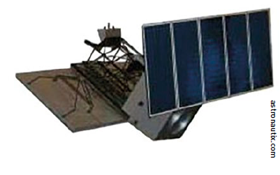
 Tianhui 1 topographical satellite.
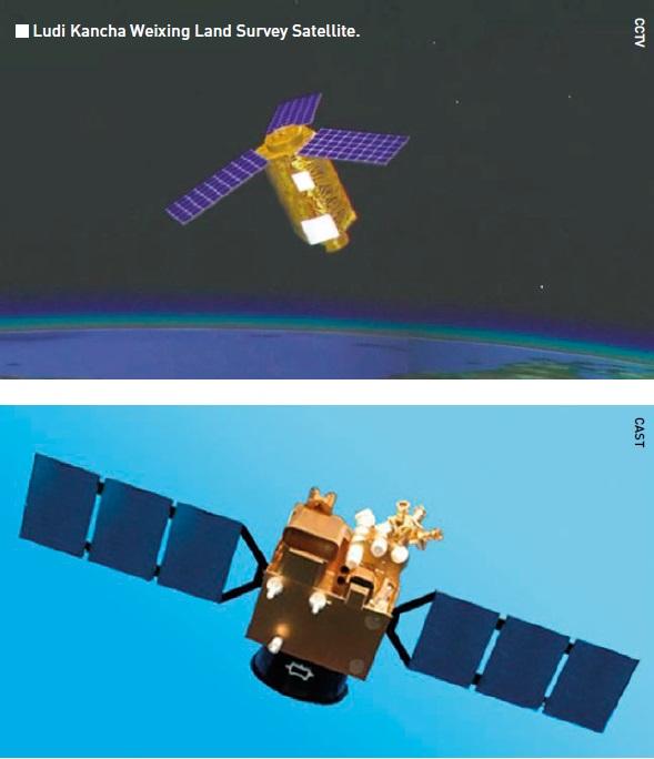
Ludi Kancha Weixing (LKW)
LKW is a high-resolution optical Earth observation satellite for military purposes. Chinese media have stated that the satellites are used for remote sensing exploration of land resources. However, the secrecy surrounding the LKW satellites is extreme, even by Chinese standards, giving credence to the theory that they are part of the country’s military topographical reconnaissance efforts.
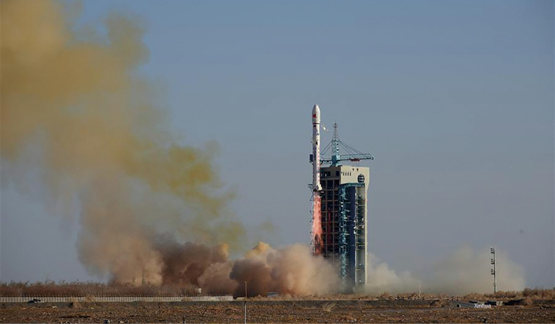
Looking at the parameters, LKW satellites appear to be connected to the Yaogan reconnaissance satellite fleet. Based on its appearance - a hexagonal satellite body with three radial fixed solar panels - the satellite is likely suitable for hosting a telescope of about 65 cm and thus, in a 500 km orbit, achieving a possible ground resolution of up to 0.7 m for panchromatic (PAN) sensor images and better than 3 m for multispectral and near-infrared images. Two satellites were launched in 2017 and two more in 2018. This rapid pace of deployment was previously only seen in military-operated satellite projects.
Tianhui Yi Hao Weixing
Officially, the purpose of these [Yaogann 30] satellites is to “conduct technical experiments on the electromagnetic environment,” a euphemism for electronic intelligenceTianhui
Tianhui is a collective name for a network of several topographical satellites, built by Dong Feng Hong and operated by the People’s Liberation Army. It includes Earth observation missions using optical, radar, gravity and magnetism sensors to obtain geo-information about the Earth.
The programme provides for the launch of nine satellites of six different types to obtain quantitative research of the Earth’s land, sea, gravity and magnetic field. These satellites will form a space-based Earth observation network to conduct both basic Earth surveys and detailed surveys for key areas or in response to an emergency.
Tianhui 1 satellites are part of the Ziyuan programme which includes several civilian and military remote sensing programmes. Four satellites of this type have been launched [2010 - 2021] to 500 km SSO. The satellites are equipped with two different camera systems, one of them in the visible range (5 m resolution), and the other in the infrared band (10 m resolution).
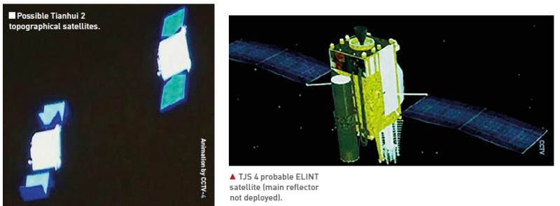
Tianhui 2 satellites will be used, according to state media, to conduct land surveys, mapping and scientific experiments in space. The Tianhui 2 series is the first microwave measurement system for China to use interferometric synthetic aperture radar (InSAR) technology, working together in pairs (the satellite system is probably similar to the German TanDEM-X satellite system). Tianhui 2 satellites are believed to operate in the X-band and have a resolution of 3 m.
The first group of two satellites was launched in 2019. The mission was not announced in advance by China and notices for the launch (NOTAMs) were not filed with aviation authorities. The satellites were launched into almost the same (type of) orbit [500 km SSO] as the four Tianhui 1 satellites. There is no Tianhui 3 satellite as of now. The Tianhui 4 satellite [2021] will, reportedly, observe the Earth in both the visible and infrared spectrum using two cameras with a resolution of less than 5 m.
 TTJS 4 probable ELINT satellite (main reflector not deployed).
Tongxin Jishu Shiyan Weixing (TJS)
TJS is a series of Chinese satellites that have been deployed in geostationary orbit since 2015 and presented by Chinese authorities as telecommunications satellites. Specific features have not been published and the real purpose of each satellite is therefore questionable. The behaviours exhibited by these satellites indicate a mixture of applications.
All TJS satellites are in geostationary orbit (GEO). Some appear to be built for missile warning (built by the Shanghai Institute of Satellite Engineering), while others seem to operate like signal intelligence satellites (built by CAST, a Beijing based satellite factory). According to the Shanghai Academy of Spaceflight Technology, TJS 6 and TJS 7 have experimental docking stations.
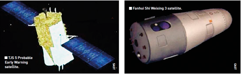
Because of the limited information available and the lack of published outcomes they are considered by Western observers to be military satellites. It cannot be said with any certainty what kind of (military) satellites the launched TJS 3 and TJS 7 [2018, 2021] are. There seems to be no TJS 8. TJS 1, 4 and 9 [2015, 2019, 2021] are assessed to be electronic intelligence (ELINT) satellites. They are sometimes also referred to as Qianshao-3 or Chang Cheng. Reportedly, TJS 1 successfully deployed China’s first large aperture reflector antenna (c. 32 m) after it reached GEO.
TJS 2, 5 and 6 [2017, 2020, 2021] are assessed to be for early warning of ballistic missiles. They are sometimes also referred to as Huoyan. The name Huoyan means Fire Eyes, which may suggest infrared sensors.
JIANBING MILITARY REMOTE SENSING SATELLITES
Chinese military reconnaissance satellites are usually categorised based on their military Jianbing (group) designation. The first Jianbing group were the first generation of Fanhui Shi Weixing photo reconnaissance satellites [1975]. The first Yaogan satellite, as most military remote sensing satellites have been publicly called since 2006, was the first of the Jianbing 5 group.
Since 2015, the Jianbing-Yaogan relationship is no longer very clear and Western analysts differ on the naming convention. Yaogan satellites primarily support the People’s Liberation Army and may support civil causes too. They utilise various means of remote sensing e.g. synthetic aperture radar (SAR), electro-optical reconnaissance (EO), and electronic intelligence (ELINT) for Ocean Surveillance.
Fanhui Shi Weixing (FSW)
This satellite programme was conceived and developed in the late 1960s. From 1975 to 1996 there were some 17 launches and recoveries of three generations of FSW satellites (military designation Jianbing 1). Military reconnaissance was carried out using photographic film, from a prism-like panorama camera, which, after recovering the photo capsule, was developed on Earth. Under the Jianbing 2 and 4 name, six more, improved, FSW satellites were launched [2003-2005]. The Jianbing 3 name was reserved for the three Ziyuan 2 Earth observation satellites [2000-2004]. The FSW programme is assessed to be terminated.
 Jianbing 7 SAR reconnaissance satellite.
Yaogan (Jianbing) - synthetic aperture radar (SAR)
One of the main objectives of the Jianbing Ocean Surveillance programme is to put an end to the near invulnerability of US aircraft carriers
Jianbing 5 was the first-generation SAR reconnaissance satellite. The satellite (2,700 kg) was equipped with an L-band SAR system with two working modes with 5 m and 20 m resolution respectively. The satellite operated in a polar orbit of 630 km/98 degrees. In total, three missions of this series have been launched (see Table over leaf).
Jianbing 7 is believed to be the second-generation radar reconnaissance satellite. Operating from a polar orbit of 510 km/97.4 degrees, the satellite is equipped with a SAR package that offers a spatial resolution of about 1.5 m. Since 2009, a total of four missions have been launched. Jianbing X is believed to be a new type of SAR reconnaissance satellite. Yaogan 29, 33 and 33R are associated with this name.
Yaogan 29 [2015] operates from a polar orbit of 615 km/97.3 degrees and is equipped with a SAR package that may offer a spatial resolution of better than 1.5 m. It is possibly an improved Jianbing 5. Some analysts refer to this satellite as Jianbing 12.
Yaogan 33 [2019] was believed to be the second Jianbing X launch, but it failed.
Yaogan 33R [2020] was initially seen as a replacement for Yaogan 33, but used a different launch site and a higher orbit of 682 km/98.7 degrees. There is a lot of ambiguity and confusion between analysts.Reportedly, the 33R is not related to the 33, but the name would have been reused. Either way, the satellite payload is believed to be a radar satellite of a new series, but details are unclear for now.
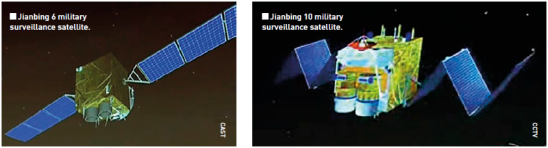 Jianbing 6 military surveillance satellite.
Yaogan (Jianbing) - Electro-optical
The Jianbing 6 group consists of electro-optical reconnaissance satellites. The satellite is 3-axis stabilised, with track manoeuvring ability. Operating from a 630 km-high SSO, the satellite is able to capture images of the Earth with a spatial resolution of about 1.5 m. The satellite has an X-band data link for sending image data to dedicated ground stations. A total of six missions have been launched so far.
Jianbing 10 is the second-generation electro-optical reconnaissance satellite developed using the Phoenix Eye satellite bus. This versatile bus is designed for SSO and has also been used in the Ziyuan 2 and CBERS Earth observation satellites programmes. The optical payload has a spatial resolution of 0.77 m. A total of three missions have been launched.
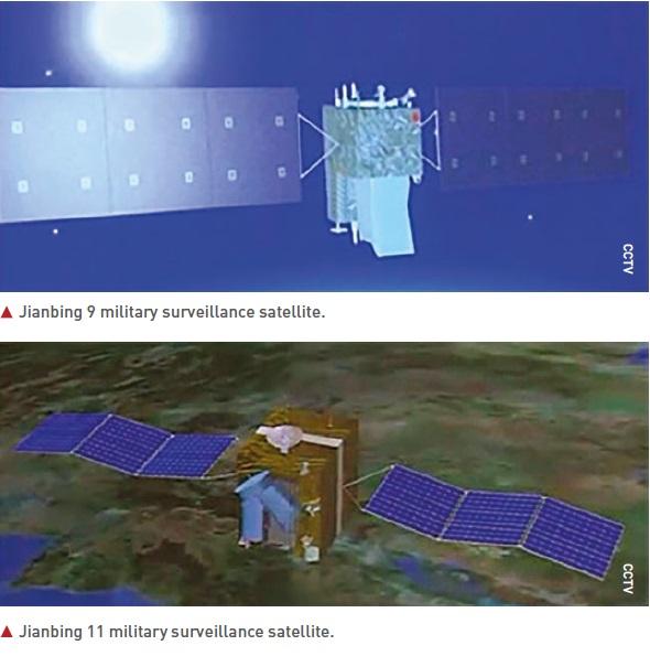
Jianbing 9 is believed to be the third generation of electro-optical reconnaissance satellites. The satellite’s imaging package was developed by the Changchun Institute of Optics. The satellite operates at a much higher altitude than previous Chinese electro-optical satellites, in a 1200 km-high orbit with an inclination of 100.3 degrees. Since 2009, a total of five missions have been launched.
Jianbing 11 is a high-resolution electro-optical reconnaissance satellite, possibly the successor to the Jianbing 10 group of satellites (fourth generation). Operating from a 490 km-high SSO, it is believed that the satellite is capable of delivering images with a resolution of less than one metre. Since 2012, two missions have been launched.
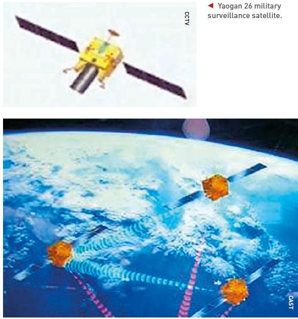
According to the website China.org, the Yaogan 26 satellite will be used as a new remote sensing device for scientific experiments, land surveys, crop yield assessments and disaster monitoring. However, analysts believe that this class of satellites is used for military purposes. Developed by CAST and based on the Phoenix Eye-2 platform, the satellite is likely capable of high-resolution observation and also carries an infrared sensor. Western analysts differ widely on the name combination this satellite should have.
![Jianbing satellites [SCS, 1 September, 2022]](/images/contents/issue33-Jianbing-satellites.jpg)
Yaogan (Jianbing) - Ocean Surveillance
One of the main objectives of the Jianbing Ocean Surveillance programme is to put an end to the near invulnerability of US aircraft carriers: an aircraft carrier and its associated naval air group are extremely well defended. They are also very mobile, which is problematic, because before you can threaten them, you must find them.
A ship sailing at 20 knots can travel more than 800 km a day, so geolocating a naval air group in the middle of the ocean is a difficult game of hide and seek. Jianbing 8 can only detect ships if they emit electromagnetic energy (radar, communication). Jianbing 8 is also likely able to detect early warning aircraft launched from an aircraft carrier, giving a general idea of the aircraft carrier’s location.
The Jianbing 8 constellation is formed of three satellites in three orbital planes, at 63 degrees inclination. The satellites, possibly consisting of a primary satellite and two sub-satellites, are launched in a triplet similar to that of the US satellite constellation NOSS/Whitecloud, which is used to detect, identify and locate radar and telecommunication emissions, particularly those from warships. This Jianbing constellation likely performs this function by locating them using a technique in which the time difference of arrival of emitted signals is measured and used to triangulate. Since 2010, nine such triplets have been launched.
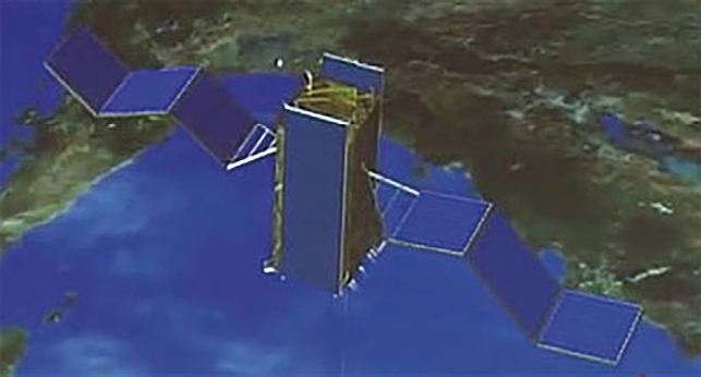
 Jianbing 8 satellite constellation.
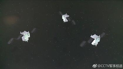
On 6 November, 2021, China successfully launched a triplet of satellites, Yaogan 35 01-A, -B and -C. The satellites were placed in a circular orbit of almost 500 km/35 degrees. Before the launch, China reported that the satellites would be used for “scientific experiments, land and resource logging, and other areas”, but that is likely a generic explanation to hide the satellites’ true purpose. It is believed that they may in fact be a continuation of the Jianbing 8 triplets and have a role in intelligence gathering. After the first successful launch, three more were executed in 2022.
Chuangxin 5 (Yaogan 30) - Ocean Surveillance
It is questionable whether the Yaogan 30 constellation is dedicated to ELINT: the only clues in this direction are images and official statements, which may be disinformation
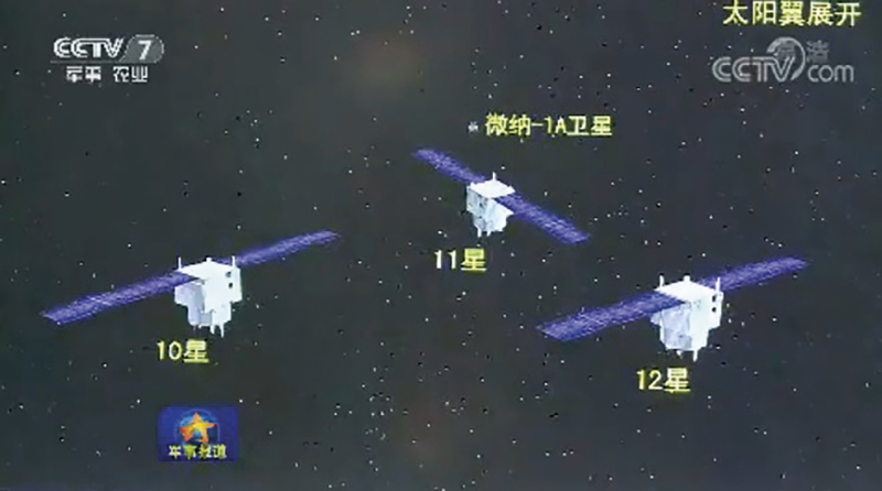
Yaogan 30 triplets are a relatively recent addition to China’s satellite detection system. The first triplet of this type was launched on 29 September, 2017, under the designation Yaogan 30 01-A, -B and -C. Officially, the purpose of these satellites is to “conduct technical experiments on the electromagnetic environment,” a euphemism for electronic intelligence. This is consistent with the fact that ELINT satellites are often launched in triplets, such as the Jianbing 8 triplets. The advantage of a triplet is that satellites flying in tight formation, a few tens of kilometres away from each other, can triangulate and accurately locate the source of an electromagnetic signal. This is more difficult to achieve with a single satellite. However, the Yaogan 30 satellites do not fly in formation. The Yaogan 30-01 trio separated after launch and were placed 120 degrees apart. They are therefore too far apart to be able to triangulate signals, because there is not even an unobstructed line of sight between them.
 Yaogan 35 triplet of satellites.
On the other hand, this type of layout corresponds to what is expected if three satellites are positioned to maximise their visit frequency. Moreover, the satellites have good coverage of the Pacific Ocean, India, China, North Korea and even Japan thanks to their low orbital inclination, the latitude that is important for China’s defence. In addition, the height of the track is remarkably low for ELINT satellites: usually these are placed relatively high, at about 1000 km altitude, to increase their field of view.
Imaging satellites, on the other hand, are placed low to increase their resolution while maintaining an acceptable field of view. Therefore, it is questionable whether the Yaogan 30 constellation is dedicated to ELINT: the only clues in this direction are images and official statements, which may be disinformation. The satellites could very well be small optical satellites that offer a high frequency of repetition. Up to July 2021, ten triplets of Yaogan 30 satellites had been launched.
The Yaogan 32-01-01 and 32-01-02 are a duo of military satellites with an unknown purpose. The visualisation during the launch broadcast by China Central Television (CCTV) hints at signals intelligence (SIGINT)satellites. They were launched on 9 October, 2018; a second launch took place on 3 November, 2021.
The Yaogan 34 satellite is possibly the first of a new series of government optical remote sensing satellites, likely also used as military reconnaissance satellites. The satellite was described as an optical remote sensing satellite, mainly used in territorial research, urban planning, confirmation of land rights, road network design, crop yield estimation, disaster prevention and mitigation and other areas. Yaogan 34, was launched in April 2021, Yaogan 34-02 followed in March 2022, in a 1100 km/63.4 degree orbit.
The Gaofen 11 series was billed as a civilian Earth observation system but was militarily codenamed Jianbing 16.
 Yaogan 30 triplet of satellites.
About the author
Henk Smid is a retired chief officer of the Royal Netherlands Air Force, space analyst and author of numerous space related articles (https://smid.one). He has been an advisor to several national and international working groups on space-related topics for which he has prepared/written a series of analyses and projections [Defence, NATO, European Commission]. Henk Smid gives lectures on space systems and technologies.