

Man-made space debris and dangerous celestial bodies (DCS), such as asteroids and comets, present a great potential threat to Earth and it is essential to create a data analysis system that would automatically process large amounts of incoming data from combined monitoring of near-Earth space and early warnings systems.
Such a system would integrate a number of data factors - data analysis, comparisons of statistical and monitoring data on various risk factors, simulated situation scenarios and aftermath predictions.
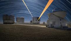
Modern space observation systems allow for precise monitoring, cataloguing and forecasting of potential areas where space objects and their fragments may fall and an early warning system, both for public use and for that of various emergency services, is vital.
At the same time, the smaller in size the observed object, the less likely it is to register as a potential threat. This makes it necessary to constantly monitor, collect and analyse data received from observation points (based both in space and on Earth’s surface), as well as process large amounts of incoming data on dangerous celestial bodies.
It is important to determine the size and precise orbital parameters of space objects - as these are the main factors in determining potential danger - as well as calculate the probability of a close encounter with Earth. Once such information is obtained and systemically analysed, responsible decisions by appropriate agencies can be made about the necessary preventative measures and actions for preventing a possible collision.
Considering this issue is vital for human safety all around the world and international cooperation is necessary to help prevent and manage asteroid, comet and space debris-related emergencies.
The goal of DCS monitoring and data analysis is to create a methodology and software system that will ensure space object data is received and processed, proper calculations are made, a mutual data exchange is organised, forecast models are created and data on potentially dangerous objects is catalogued.
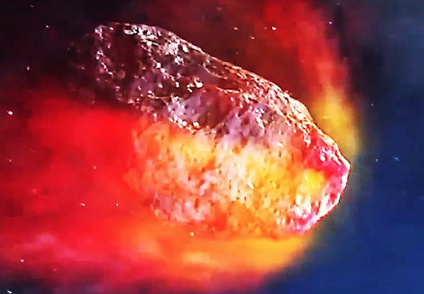 Artist’s impression of an asteroid entering Earth’s atmosphere
There are a number of information systems, databases, and open Internet resources that monitor and analyse such dangers: the Minor Planet Center at the Jet Propulsion Laboratory; the Small Bodies Node (SBN), part of the Planetary Data System at NASA; and the Near Earth Objects Dynamic Site (NEODyS).
Russia has also developed its own software, programs and databases. These include EPSSOR (Ephemeris Program for Solar System Object Research) developed in Pulkovo observatory; AMPLE 3 software package (Adaptable Minor Planet Ephemerides) developed in the Applied Astronomy Institute at the Russian Academy of Sciences (AAI at RAS); ‘Ida” software application suite, developed by Tomsk State University; Solar System Small Body Orbital Evolution Catalogue, developed at the applied mathematics and computer science department at Samara State Technological University; ‘Cluster’ information system - a periodically renewed database of Solar System small bodies that was created in 2005 at the Astronomy Institute at RAS (AIRAS) and includes a number of programs that automate database updates and observation results processing.
These projects are highly important from a practical standpoint. However, their primary goal is to catalogue celestial bodies and they are not able to accurately predict the after-effects of a dangerous space object colliding with Earth.
At the same time, data and monitoring centres at agencies such as the Ministry of Emergency Situations of Russia, Ministry of Defence of Russia, Roscosmos and others, have functional automated control systems that monitor dangerous space objects - and their goal is to discover, analyse and predict the consequences of DCS-related emergencies.
The main goal of the Space Tracking System (STS) at the Ministry of Defence of Russia is to observe Earth’s artificial satellites and other space objects. The system is considered part of the Aerospace Defence Forces and the Space Surveillance Control Center (SSCC) maintains a catalogue of STS space objects.
This catalogue is meant as a long-term data storage unit of orbital measurements, optical, radar-location, radio-technical and other special data about all man-made objects located 120 km to 40,000 km above Earth. The catalogue lists 1500 characteristics (its number, attributes, coordinates, orbital characteristics, etc) for each space object.
In 2012, the Main Information and Analysis Centre at the Central Science and Research Institute of Engineering (SCRIE), the head institute of the Russian Federal Space Agency, began using an automatic warning system (ASPOS) for dangerous situations in near-Earth space. However, the usefulness of this and other Russian systems is largely limited by agency-level goals, such as controlling safety zones for spacecraft flights, spaceflight control, monitoring distance between space objects and spacecraft, and cataloguing space objects.
NORAD (North American Aerospace Defense Command) has similar goals, mainly to provide control over airspace and near-Earth space over North America, and manage early warnings in case of aerospace attacks, air and anti-missile defence.
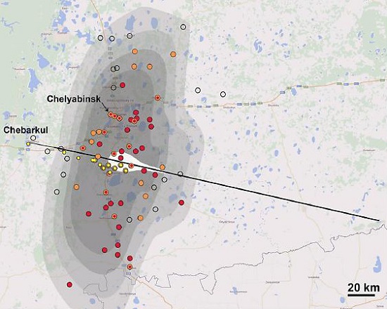 Diagram showing the increased pressure at the time of the Chelyabinsk meteorite impact
In 2014, the authors of this article helped develop and test a demo of a data analysis system for monitoring dangerous celestial bodies and planning countermeasures at the Russian Centre for Monitoring and Forecast of Emergency Situations at the Ministry of Emergency Situations of Russia (‘AntiStikhia’ Centre). Test results confirmed that the technical approaches and methodology used were correct and that it is necessary to continue developing the data analysis system (DAS).
DAS structure and operation
The data analysis system for combined monitoring of near-Earth space objects and early warning notification is a unified system of software tools developed on the basis of scientific methodology and systems for warning and managing emergency situations.
Their primary goal is to catalogue celestial bodies and they are not able to accurately predict the after-effects of a dangerous space object colliding with Earth
The purpose of DAS is to locate celestial bodies on a collision trajectory with Earth within a time frame ranging from a few hours to a few decades and pinpoint the risk zone on Earth where the body may fall. The system processes incoming data, detects close encounter incidents of dangerous asteroids and large space debris, and evaluates the level of risk of collision while taking into account the possible crash site’s infrastructure.
The major components of the data analysis system are:
- a databank for collecting and archiving data from various sources
- a subsystem of automated data collection
- a forecasting and analysis subsystem for determining a space object’s characteristics (orbit, physical and chemical characteristics, long term orbit evolution) and assessing potential damage in case of the body’s collision with Earth
- a visualisation, data and result publishing subsystem
- administrative tools for database support and facilitated interaction with related systems and user accounts.
An essential aspect of the data analysis system is an integrated catalogue of potentially dangerous objects, including databases of potentially dangerous celestial body movement, long-term observations of dangerous celestial bodies, and collision course simulations.
Data collection subsystem
The subsystem is a single software module intended for automatic data collection, verification and control of received DAS data. Data is composed of information compiled by international near-Earth space monitoring centres and manual data entry by system operators. The subsystem also provides automatic control of entered and imported data by comparing it to reference materials.
Forecast analysis subsystem
The forecast analysis subsystem is the main component of the data analysis system. It processes incoming data and assesses the current situation in near-Earth space, calculating the trajectory of dangerous objects prior to their entry into Earth’s atmosphere. The subsystem includes a series of software modules that performs tasks, including: determining the orbits of celestial bodies, researching orbit evolutions, assessing the possibility of celestial bodies coming into close contact with Earth, and evaluating the after-effects of a collision with a celestial body.
Initial information about orbits is obtained from the asteroid catalogue after which speed, location and angle of entry into the atmosphere are calculated as an approximation of the potential collision course with Earth (based on the ellipse of the object’s orbit).
If this approximation is more than zero, the object’s orbit is calculated using numerical integration that allows one to build the DAS trajectory, taking into account the disturbance input from Earth, the Moon and planets. Calculations of close encounters of near-Earth asteroids are performed automatically. The probability of collision and possible crash sites, as well as predictions of the angle and speed of atmosphere entry are also calculated.
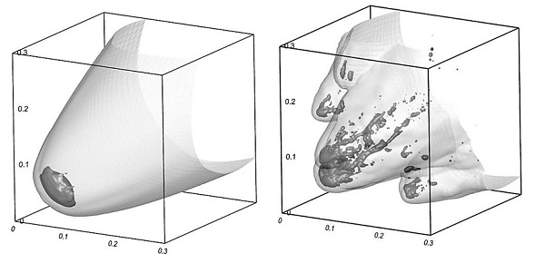 Results of a simulation showing the destruction process of a meteoroid of cometary origin
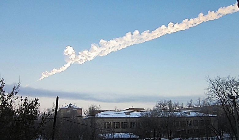
In order to assess the consequences of collision with a celestial body and the level of danger at an impact site the location site and its infrastructure, physical, mathematical and numerical models that describe the complex processes of DAS interaction with the atmosphere and Earth’s surface are used. These methods were used to simulate the trajectory of the Chelyabinsk meteorite 60 days prior to its fall. Its trajectory was simulated in order to demonstrate system use in the case of a real object - both regarding the conditions of its fall and the aftermath caused by the fall.
The 20 m object blazed across the Ural Mountain skies near the town of Chelyabinsk at just under 20 km/s, detonating in the atmosphere with an explosive yield approximately 25 times that of the bomb dropped on Hiroshima. Over 1500 people were injured, most due to flying glass shards from the over 7200 buildings damaged by the shock wave.
Considering the large volume of calculations, the development of a specialised database containing previously made collision calculations is also planned. This will help create a full database of adverse factors for all possible scenarios which will be used to build an interpolating computer model that will be able to assess the after-effects of DAS collisions with Earth in a timely manner.
Visualisation and data publishing subsystem
This subsystem reflects the original data and the results of the prediction analysis subsystem calculations. It contains a module for generating reports and presenting analytical information in tables, graphs, animations and maps with the use of geo-data and OLAP-technology, and a module for exporting reports in standard word processing formats and html-files.
The purpose of DAS is to locate celestial bodies on a collision trajectory with Earth and pinpoint the risk zone on Earth where the body may fall
Experience has shown that territorial positioning and hierarchal systematisation of databases, as well as developing methods of obtaining spatial analytical samples and map models, should be included as part of creating an autonomous integrated service that provides geo-data functions of organisation, storage, analysis and spatially coordinated data presentation. This approach allows for the use of modern network solutions that support and work well with databases based on geo-data technological solutions integrated with web applications.
References
1V.N. Lvov, S.D. Tsekmeyster. Using the EPOS software package for the study of solar system objects. // Astronomy Herald. 2012. V. 46. ? 2. P. 190.
2N.B. Zheleznov, F.A. Novikov, V.A. Shor, Y.D. Medvedev, T.G. Vega, O.M. Kochetova, G.A. Netsvetaeva, O.A. Bratseva, U.N. Tikhonova, I.N. Netsvetaev, R.V. Kovtun AMPLE 3 - a multi-purpose software package for the study of minor planets and comets // Papers of the Institute of Applied Astronomy. 2010. No 21. Pp. 230-235.
3L.E. Bykova, T.U. Galushina, A.P. Baturin. Application software system ‘IDA’ for the study of asteroid dynamics // Universities News. Physics. 2012. V.55. No 10/2. Pp. 89 - 96.
4A.F. Zausaev, V.V. Abramov, S.S. Denisov. Catalogue of orbital evolution of asteroids that have and will approach Earth from 1800 to 2204. - M .: Mechanical engineering - 1, 2007. - p. 608.
5S.A. Naroenkov. Electronic data processing of Solar System small bodies information system. // Higher Educational Institutions news. Geodesy and aerial photography. 2009. No 3. Pp. 38-45.
6S. Yuferev ‘No satellite will escape the space control system’ // Military Review, 2015, http://topwar.ru/72587.
7V.P. Kulagin, B.M. Shustov, Y.M. Kuznetsov, A.F. Kaperko et al. Methods and tools for data analysis assessment of asteroid and comet hazards // Lavochkin SDPC News. 2015. No 4 (30).