If industries, institutions, regulatory bodies and policymakers have access to emissions data that independently verify when, where, how much and at what rate natural gases (like methane) are being emitted into the atmosphere, we can slow global warming, accelerate our path to net-zero and harness crucial financial and technological opportunities across industries. It’s that simple: data is the fuel that makes climate action possible.
Detecting methane presents several challenges. Just like CO2, methane is both colourless and odourless, requiring specialised equipment for its identification. Leaks can occur at numerous points along the oil and gas value chain, from extraction to storage, making detection efforts more cumbersome, expensive and difficult to carry out. Moreover, many oil and gas facilities are located in remote areas, making conventional monitoring and leak detection techniques even more difficult.
Credible, verified emissions intelligence on a global scale means that leaks, flares, and super-emitter incidents can be detected, monitored and stopped efficiently, accurately and transparently. This capability is essential if we’re going to succeed in cutting greenhouse gas (GHG) emissions by 43 percent by 2030.
Current monitoring solutions include advanced sensors, drones and remote aerial imaging. While on-site sensors that use bottom-up technologies can sound the alarm when a leak occurs and provide limited emissions estimates, drones and other remote imaging provide a bird’s-eye view of remote and offshore facilities, detecting leaks and flares. These aerial images complement ground-based monitoring efforts, offering a comprehensive understanding of methane emissions from offshore oil and gas installations.
However, there are three major issues with these solutions: scale, cost and precision.
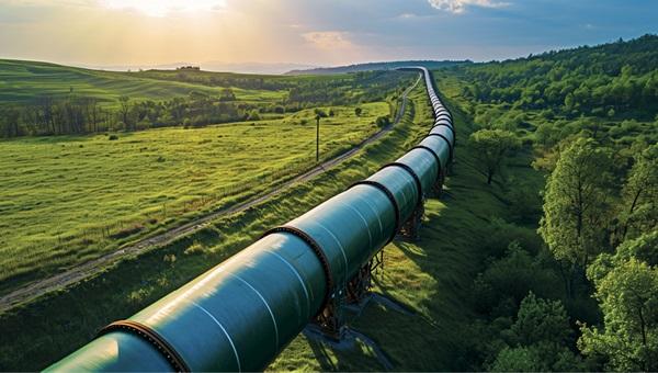 There are 500,000 miles of natural gas gathering pipelines in the US. Only seven percent are inspected for leaks.
AI & multi-satellite imaging
This data is also crucial for financial institutions and investors, enabling sustainable and green decision-making with transparency
Harnessing satellite imagery to detect emissions overcomes these challenges and takes emissions detection, monitoring and reporting to the next level.
Over the last decades, we’ve seen an explosion of interest, investment, and technological advancement in space. The staggering proliferation of satellites in orbit has opened up new avenues for imaging, monitoring and understanding every square metre of planet Earth - detecting and measuring GHG emissions is no exception.
Satellite imagery overcomes obstacles
Detecting emissions in satellite imagery with technology provides a scalable, cost-effective, and precise view of methane emissions over vast regions and, importantly, over time.
By applying advanced algorithms to images from a wide range of satellite imagery for any given area of interest, the precise location of super emitters, flares, and leaks can be identified with verifiable measurements and crucial historical data. This enables industry operators and regulators to track emissions accurately over time.
How it works
As sunlight travels through the atmosphere, it is absorbed and re-emitted by any gases it encounters, with certain gases emitting energy at specific wavelengths, ie, their ‘spectral signature’.
When proprietary algorithms are applied to these images with the relevant spectral data, they can autonomously identify, quantify and categorise natural gases like methane.
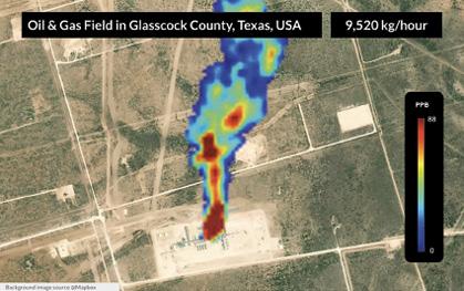 Methane emission from a gas processing plant in Texas, USA.
Advanced emissions intelligence
Satellite technology is the future of emissions monitoring, driving us towards a sustainable, net-zero world
Emissions intelligence from multi-satellite imagery empowers diverse sectors, governments, and regulatory bodies to know exactly where natural gasses are being emitted and at what rate. This level of accuracy and geographic scale is unattainable with other monitoring solutions.
Data-driven solutions reveal the unseen by identifying, quantifying and monitoring actual emissions and potential sources on a global scale. By understanding these patterns, industries and governments can implement targeted emission reduction strategies, further enhancing our global sustainability efforts. This data is also crucial for financial institutions and investors, enabling sustainable and green decision-making with transparency.
The only way forward
This is emissions monitoring on the next level - the only level that will get us to net-zero by mid-century. For decades, undetected amounts of dangerous and potent contributors to global warming have been released into the atmosphere across industries. Efforts to identify and monitor these emissions on a global scale have largely relied on estimates, calculations, and monitoring solutions requiring human guidance and costly hardware.
However, this is changing, and the way we get to net-zero is evolving with it. This is not just a possibility; it’s a necessity. Satellite technology is the future of emissions monitoring, driving us towards a sustainable, net-zero world.
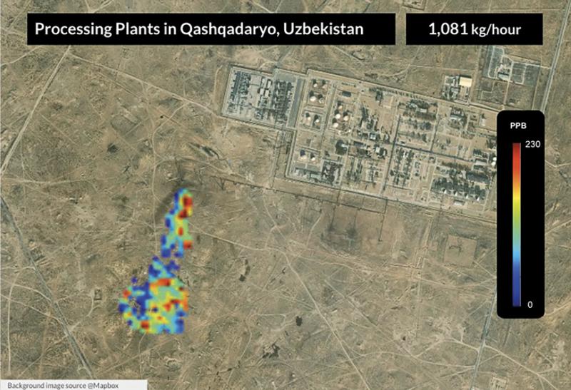 Methane emissions autonomously detected and monitored by Momentick’s algorithms in multi-satellite imagery.
About the author
Dr Adam Eshel is the VP of R&D at Momentick, an emissions intelligence company helping companies detect their emissions using space imagery on a global scale. He holds a PhD from Tel Aviv University in Atmospheric Physics, jointly with Electrical Engineering, and was a research collaborator at the Karlsruhe Institute of Technology (KIT). Starting his career as an algorithm and signal processing engineer, Dr Eshel’s journey reflects a strong commitment to innovation, practical application of research and passion about climate-related issues.


