In a relatively short space of time, ever-present connectivity has become an essential requirement for modern society. Individuals, businesses and institutions rely on it to function safely and effectively, and the demand for high-speed data transmission is ever growing. Although there are clear advantages to using higher frequencies, a key disadvantage is the effect of weather conditions, as this article explains.
The satellite industry is increasingly using higher radio frequency bands, such as Ka-band, for High Throughput Satellites (HTS) and Very High Throughput Satellites (VHTS). Higher frequency bands provide the bandwidth required for various high-speed data and communication services, including broadband internet and live television broadcasting.
Although there are many advantages to using higher frequencies, they are much more susceptible to weather-related outages than frequencies at the lower end of the spectrum. This is problematic for several reasons.
Satellites provide critical services, such as those used for air traffic control, emergency response and military operations, and are essential for public safety. Thus any interruption or outage can have serious consequences and can put lives at risk.
In addition, consumers have come to expect an uninterrupted service, so if an operator experiences frequent outages, it can damage their reputation and erode customer confidence in their services. This can lead to loss of customers, which is obviously extremely costly. Responding to and resolving outages can also be time consuming for operators, which again adds to further avoidable costs being incurred.
If Ka-band is so easily affected by weather, and has the potential to cause operators these significant problems, why are they choosing to use it at all? To better understand the advantages that Ka-band brings, as well as the challenges its use presents to the satcom industry, we first need to consider how higher and lower frequencies differ, and how the technology used to distribute the signals differs.
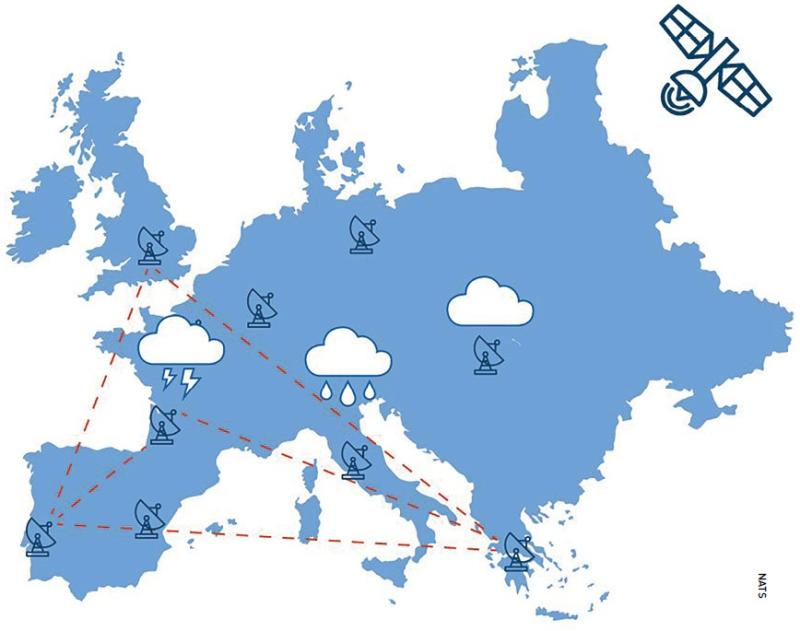 Key European ground station locations.
Advantages of Ka-band
Traditional satellite networks operate at lower frequency bands, such as Ku-band, which is within the range 12 to 18 GHz, and the even lower C-band which is between 4 and 8 GHz. Higher frequencies include Ka-band, defined as within the range 26.5 to 40 GHz, Q-band between 33 and 50 GHz, and V-band between 40 and 75 GHz.
Although Ku-band provides higher throughput compared to C-band, it still provides considerably less than Ka-band. To illustrate this, consider the ViaSat-1 satellite which claimed a Guinness World Record in 2013 for being the ‘Highest Capacity Satellite’ at that time. It was one of the first high throughput satellites to be launched and it provided 100 times the capacity of a typical Ku-band satellite.
Although there are a number of advantages to Ka-band, probably the most important is that higher frequencies provide higher data transmission rates and increased bandwidth. To put it simply, signals travelling at higher frequencies make more wave oscillations per second of time, so they can carry more data. This enables satellite operators to provide faster internet speeds and more data-intensive services to customers.

High throughput satellites utilising Ka-Band distribute the signal in a different way to conventional satellites using lower frequencies. The principal benefit of HTS is frequency re-use through the use of spot beams. With a conventional satellite, a global beam is spread out over a wide area, possibly covering a whole continent, but this means that each frequency can only be used once in the whole beam, so the spectral efficiency is low, which limits the overall satellite capacity. If a satellite uses spot beams, the same frequency can be used many times dependent on the number of beams, resulting in much better spectral efficiency, improving coverage, capacity and bandwidth. Some HTS operators, although not many, use Ku-band for HTS; this gives them the benefit of frequency re-use but not the benefit of the higher data capacity of Ka-band.
Higher frequencies/shorter wavelengths also impact the physical size of the hardware and mean that ground terminals are more compact, often easier to install and maintain, and more cost effective. This opens up satellite connectivity to new markets and applications. Historically, higher frequencies have also tended to be less congested than lower frequency bands because there is more availability of spectrum. However, this is rapidly changing for Ka-band and is driving satellite operators to use Q/V-bands for the satellite uplinks (known as feeder links).
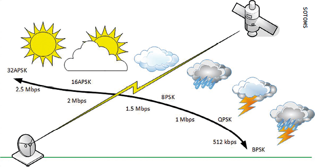 Adaptive Coding and Modulation (ACM) is used to prevent outages caused by atmospheric conditions like rain fade, changes in RF levels, solar events, noise or interference.
Effect of weather
Although there are many advantages to using higher frequencies, they are much more susceptible to weather-related outages than frequencies at the lower end of the spectrum
So, what effect does weather have on the signals? When a satellite signal passes through the atmosphere, it can be affected by various atmospheric phenomena including precipitation, cloud, atmospheric gases (water vapour and oxygen) and turbulence.
Wet weather events such as rain, wet snow and thunderstorms can cause significant signal attenuation, known as rain fade. This happens because the electromagnetic signal transmitted between the satellite and the ground terminal is weakened because of scattering and absorption from rain droplets. The depth of the rain fade is dependent on the frequency of the signal and the size of the raindrops. The effect is worse for the higher frequency bands because the wavelength of the radiation is closer to the size of the rain drops, which more easily absorb the energy. Thus the presence of moisture in the path of the electromagnetic waves results in a significant reduction in signal strength and quality, causing service interruptions or outages.
As one would expect, extreme weather events cause more significant problems, but even slight precipitation can cause issues for Ka-band that need to be addressed. Ka-band signals are mostly affected by rain droplets in the troposphere, which is the lowest layer of the Earth’s atmosphere. Although in some regions, rain events can last for long periods of time, it is more common to have brief but very intense rainfall, which causes substantial signal attenuation. Rain is also often highly localised rather than covering a wide area.
Delivering high throughput services requires significantly more ground station ‘gateways’ than a conventional satellite network. A single gateway operating at Ka-band will typically support a data rate in the range 8 - 12 Gbps (or higher). An HTS capacity operating in the range 200 - 1000 Gbps will clearly need a vast number of gateways.
Managing these gateways is a complex process because short, intense rain showers can be highly localised, so two gateways in the same region may not experience the same rain fade simultaneously. Clearly, these multi-gateway networks need to be designed and managed to ensure they are optimised, mitigating the effects of rain and other precipitation events.
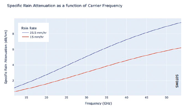 A graph of the specific rain attenuation as a function of frequency for two different values of rain rate showing that rain attenuation is increased with frequency. The expression to calculate the values has been derived from ITU-R P 838 which is a recommendation of the radiopropagation study group of International Telecommunications Union.
Mitigating weather effects
To mitigate the impact of rain fade, satellite operators rely on various techniques and technologies. Fade mitigation techniques have been developed including Adaptive Coding and Modulation (ACM), Uplink Power Control (UPC), fade margin and gateway diversity. With multi-gateway networks that form the HTS and VHTS service, operators mitigate interference from precipitation by switching to an alternate gateway.
If the operator is only able to react to the current weather conditions and switch to another gateway when conditions are already causing problems, it can be too late to avoid an outage. What’s more, having switched to a different gateway, there is always the possibility that the alternate gateway will experience weather issues later. In order to avoid weather related interference, operators need to be able to predict where weather is going to cause problems ahead of the event and this applies not only to the originating gateway, but also to the alternate gateway.
Part of the challenge that operators face when designing ground networks for HTS and VHTS services, is choosing how many gateways will be needed, and identifying suitable gateway locations that will minimise the probability of any outages from weather.
To be able to optimise performance in this way, through design of the ground network, operators need to analyse historical weather patterns. Armed with that information, operators can ensure that they design their network for the best possible network availability, and the most cost-effective network/gateway system configuration.
Moreover, to maintain the highest possible service availability for end-users, operators need to be in a position to predict outages in advance so that they can proactively switch to alternate or ‘diversity’ sites before the outage occurs. To do this, operators need to analyse weather predictions at all gateways and automatically transfer traffic to alternate gateways before outages occur. This is no mean feat.
Expanding the toolbox
As the demand for high-speed global connectivity grows, it is not surprising that Ka-band, with its advantages of high data transmission rates and increased bandwidth, is increasingly being used. However, if operators are to maximise the opportunities that Ka-band presents, they need to get much better at mitigating the negative impact of weather.
Satellite operators need effective tools to allow them to predict when and where weather events are likely to occur. They need to be able to proactively manage their network and implement preventive measures to minimise the impact of weather-related outages. Only then will operators be able to optimise HTS and VHTS multi-gateway networks in use by Ka-band satellites.
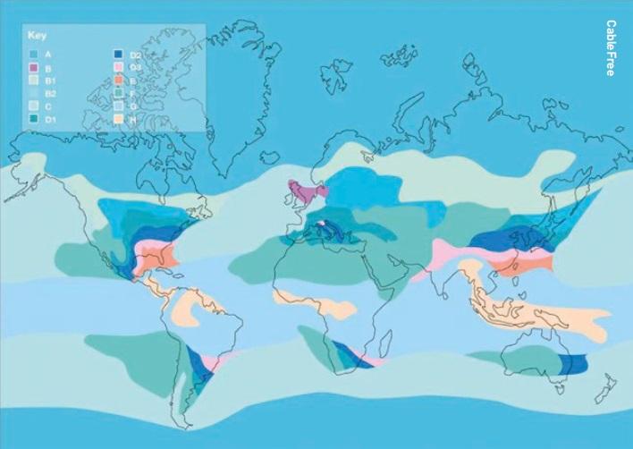 Example of a global rain fade chart for radio and microwave links showing the different rain zones by region, which is worse in the lighter areas.
About the author
John Yates is CEO of Atheras Analytics and has 35 years’ experience in the commercial satellite communications sector. After completing a BSc (Hons) in Electrical Engineering and Electronics at the University of Nottingham and a post-graduate Diploma in Business Administration at Manchester Business School, in 1986 he joined Europe’s first commercial satellite operator, the recently incorporated SES Astra, in Luxembourg and has been working in the commercial satellite communications sector ever since. Since 1998 he has worked as a freelance consultant and, more recently, as a Board Director and angel investor providing expert advice for companies, organisations and governments worldwide in the commercial satellite telecommunications sector. John co-founded Atheras Analytics with Spiros Ventouras in 2020.


