

Detailed images taken my NASA’s Perseverance rover of escarpments in Jezero crater provide evidence “once and for all” that long ago in Mars’ past, this area held enough water to form a lake and create a river delta, say mission scientists in a new study.
Jezero crater became the target of NASA’s Mars 2020 mission when observations from orbital spacecraft showed that the area resembled a prominent fan-shaped body of rock; the type associated with river deltas here on Earth.
Although spectroscopic observations from space have also detected minerals that indicate a past watery environment, what was needed was eyes on ground to scrutinise the regions stratigraphy – the order and position of rock layers – which can show the relative timing of geological deposits.
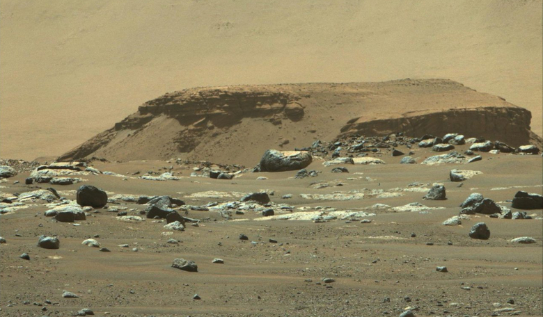
This is where Percy comes in. Using the rover’s left and right Mastcam-Z cameras as well as its Remote Micro-Imager, or RMI, a science team headed by Nicolas Mangold, at Laboratoire de Planétologie et Géodynamique in Nantes, France, set to work studying “Kodiak”; a 200 metre wide rocky outcrop located approximately 1 kilometre south of the main fan deposit.
From the images the team have interpreted this prominent butte (an isolated flat-topped hill) as an erosional remnant of an originally more extensive fan deposit.
Kodiak is comprised of layers, which say the team in their recently published paper in Science, are the result of sediments accumulating at the mouth of an ancient river that long ago fed the crater’s lake.
After seeing its distinctive layering, the team suggest this indicates delta growth into a lake system with fluctuating lake levels and because there is no evidence for later dislodgement or rotation of blocks, such as faults or slippage, this infers Kodiak has remained unchanged since its formation.
“Never before has such well-preserved stratigraphy been visible on Mars,” said Nicolas Mangold, a Perseverance scientist from the Laboratoire de Planétologie et Géodynamique in Nantes, France, and lead author of the paper. “This is the key observation that enables us to once and for all confirm the presence of a lake and river delta at Jezero. Getting a better understanding of the hydrology months in advance of our arrival at the delta is going to pay big dividends down the road.”
As significant as these findings are, misplaced boulders have also helped shed light on Jezero’s past.
Lodged into some of the upper layers of rock are stones and boulders that must have got there by episodic high-energy floods, caused perhaps by intense rainfall events or rapid snowmelt episodes from either changes in climate or volcanoes melting glaciers.
Mangold and the science team estimate that a torrent of water needed to transport the boulders – some for tens of miles – would have to travel at speeds ranging from 6 to 30 kilometres per hour (4 to 20 mph).
“These results also have an impact on the strategy for the selection of rocks for sampling,” said Sanjeev Gupta, a Perseverance scientist from Imperial College, London, and a co-author of the paper. “The finest-grained material at the bottom of the delta probably contains our best bet for finding evidence of organics and biosignatures. And the boulders at the top will enable us to sample old pieces of crustal rocks. Both are main objectives for sampling and caching rocks before Mars Sample Return.”
While it’s unknown if the lakes fluctuating water levels resulted from flooding or more gradual environmental changes, the science team has determined that they occurred later in the Jezero delta’s history, when levels were at least 100 metres (330 feet) below the lake’s highest level.
The team also think that while Kodiak was being formed, the crater was a closed lake system and had no outlet river.
Hopefully more will be gleaned from the team’s upcoming second science campaign when Perseverance will travel north then west toward Jezero’s delta region next year.
“A better understanding of Jezero’s delta is a key to understanding the change in hydrology for the area,” said Gupta, “and it could potentially provide valuable insights into why the entire planet dried out.”