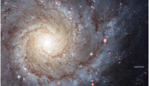
The European Space Agency (ESA) has been managing an Earth Observation Programme since the launch of its first Meteosat meteorological satellite in 1977. Following the success of this first mission, a subsequent series of Meteosat satellites, two Earth Remote Sensing satellites (ERS-1, ERS-2), and the Envisat mission provided a wealth of valuable data about Earth, its climate and changing environment. As a result, ESA has become a major provider of Earth observation data and stimulated the build-up of the Earth science community and beyond.
Started in the mid-1990s, the ESA’s Living Planet Program heralded a new approach to satellite observations for Earth science with focused missions defined, developed, and operated in close cooperation with the worldwide scientific community. As time progressed, three categories of Earth observing missions have emerged: Earth Explorer (research), Earth Watch (meteorological), and Copernicus (formerly GMES) Sentinel missions.
ERS and Envisat
Each of these missions addressed a wide range of environmental questions and predate the formal establishment of the Earth Explorer and Sentinel missions. The first European Remote Sensing Satellite (ERS-1) launched in 1991. It was ESA’s first sun-synchronous polar-orbiting remote sensing mission. ERS-1 carried a comprehensive payload including an imaging Synthetic Aperture Radar (SAR), radar altimeter, and other instruments to measure ocean surface temperature and winds. In March 2000, nine years after launch, a computer and gyro control failure led to ERS-1 finally ending its operations after far exceeding its planned lifetime.
ERS-2, which overlapped with ERS-1, was launched in 1995 with an additional sensor for atmospheric ozone research. Both satellites collected a wealth of valuable data on Earth’s land surfaces, oceans, and polar regions that were used to monitor natural disasters such as severe flooding and earthquakes in remote areas of the world. Shortly after the launch of ERS-2 in 1995, ESA operated the two satellites in the first ‘tandem’ mission mode, which lasted for nine months. Beyond the sheer increase in revisiting the same site, this tandem operation boosted synthetic aperture radar interferometry applications particularly for the generation of digital terrain models (DTMs). In July 2011, ERS-2 was retired and the process of de-orbiting the satellite began.
ESA’s Living Planet Program heralded a new approach to satellite observations for Earth science
The giant Environmental Satellite (Envisat) launched in 2002. The largest Earth observing satellite ever built by any space agency, it was an advanced polar-orbiting satellite that provided measurements of the atmosphere, ocean, land, and ice for over 10 years, double its initially planned lifetime. Envisat’s ambitious and innovative payload provided new Earth science data and also ensured the continuity of the data from the two ERS satellites.
Exceeding its predicted lifetime by a factor 3, the end still was sudden. In April 2012, contact with Envisat was lost without warning, and likely a consequence of a failure in the power-regulator or a short-circuit. However, ten years of Envisat’s archived data continue to be exploited for studying our planet with demand remaining very high even today. During 2014, about 780 new user proposals were registered at ESA asking for Envisat data. So far there are about 6500 Envisat User projects.
Earth Explorer Missions
The Earth Explorers are research missions designed to address key scientific challenges identified by the science community, while demonstrating breakthrough technology in observing techniques. These missions involve the science community right from the beginning in the definition of new missions followed by a peer-reviewed selection process ensuring that the resulting mission is developed efficiently, and that it provides the data required by the user. This approach also gives Europe an excellent opportunity for international cooperation with the global scientific community and in the area of technological development.
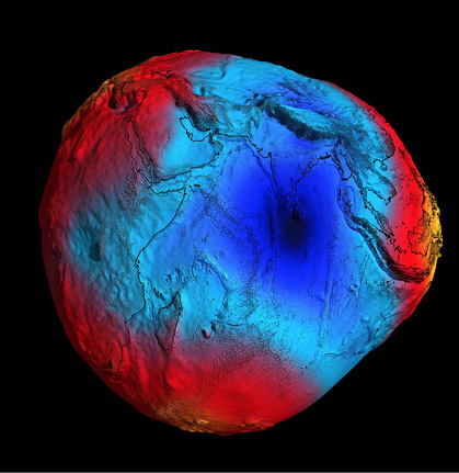
GOCE: Launched in 2009, the Gravity field and steady-state Ocean Circulation Explorer (GOCE) mission was the first of the Earth Explorers. GOCE was designed to provide information for understanding critical Earth system variables, such as ocean circulation, sea-level change and variations in ice cover driven by the Earth’s gravitational field. The gravitational gradients were measured by a set of six three-axis accelerometers. GOCE provided data to accurately determine global and regional models of Earth’s gravity field and geoid, the shape that the surface of the oceans would take under the influence of Earth’s gravitation and rotation alone. This advanced research in areas of ocean circulation and ocean dynamics, physics of Earth’s interior, geodesy and surveying, and sea-level change.
All mission requirements had been met by the end of 2012. Thus, GOCE went on to map gravity signals significantly beyond its original goal of 100-km altitude resolution. The advance meant that for the first time, global ocean currents could be extracted directly from satellite altimetry data. At the end of January 2012, GOCE’s orbit was lowered to 235 km, increasing the accuracy and resolution of the measurements to 80 km and improving GOCE’s view of smaller ocean dynamics. The satellite was further lowered to 225 km at the end of May 2013 and re-entered Earth’s atmosphere in November 2013.
SMOS: Also launched in 2009, the Soil Moisture and Ocean Salinity (SMOS) mission is making global observations of soil moisture and ocean salinity using a unique L-Band Radiometer Microwave Imaging Radiometer with Aperture Synthesis (MIRAS). Soil moisture data are required for hydrological studies and ocean salinity data are vital for improving our understanding of ocean circulation patterns. SMOS completed its nominal three-year mission lifetime in November 2012, but continues to provide valuable results beyond its initial mission objectives measuring ice thickness and wind speed. The SMOS mission exploitation phase has been prolonged until 2017.
 Earth is a complex system of interlocking parts. ESA’s Earth Observation programme aims to study all aspects of the way it works and the way human endeavours interact with it.
CryoSat-2: In 2010, Europe’s first ice mission CryoSat-2 was launched. Its principal instrument is the Synthetic Aperture Radar/Interferometric Radar Altimeter is designed to measure centimetre-scale changes in thickness of ice floating in the oceans and the ice sheet thickness that blankets Greenland and Antarctica. When combined with other satellite data, analyses showing how the volume of Earth’s ice is changing leads to a better understanding of the relationship between ice and the Earth’s climate. Cryosat-2 is providing accurate, synoptic, Arctic measurements of ice thickness and column in unprecedented detail. CryoSat’s mission exploitation phase has been prolonged until 2017.
The Earth Explorers are research missions designed to address key scientific challenges identified by the science community, while demonstrating breakthrough technology in observing techniques.
Swarm: Launched in 2013, Swarm is a constellation of three satellites that provide high-precision and high-resolution measurements of the strength and direction of the Earth’s magnetic field using an advanced magnetometer, an accelerometer and an electric field instrument. The geomagnetic field models resulting from the Swarm mission enable new insights into the Earth’s interior. They further our understanding of atmospheric processes related to climate and weather, and have practical applications in many different areas such as space weather and radiation hazards.
Future Earth Explorer Missions
Aeolus: With a target launch date in 2017, the Atmospheric Dynamics Mission (ADM)-Aeolus mission will advance global wind profile observations and provide much-needed information to improve weather forecasting. ADA-Aeolus will orbit in a Sun-synchronous, dusk/dawn orbit at 408 km and employ a highly sophisticated Doppler wind lidar with a large telescope that collects light backscattered from gas, dust, and droplets of water in the atmosphere. Data from ADA-Aeolus are expected to pave the way for future operational meteorological satellites dedicated to measuring Earth’s wind fields.
EarthCARE: With a target launch date in 2018, the Earth Clouds Aerosols and Radiation Explorer (EarthCARE) mission is being implemented in cooperation with the Japanese Aerospace Exploration Agency (JAXA). Its aim is to improve the representation and understanding of Earth’s radiative balance in climate and numerical weather forecast models. This will be achieved by global measurements of the vertical structure and horizontal distribution of cloud and aerosol fields together with outgoing radiation. The payload comprises two active instruments: a high-resolution atmospheric lidar and radar, and two passive instruments: a multispectral imager and a broadband radiometer. EarthCARE will orbit in an early afternoon sun-synchronous orbit at 393 km.
Biomass: At ESA’s User Consultation Meeting in March 2013 the scientific community made a recommendation to select the Biomass mission as Earth Explorer 7. The ESA Member States agreed in May 2013 and the final decision on full mission implementation was taken in February 2015. This mission will employ a novel P-band synthetic aperture polarimetric radar operating at 435 MHz and a 6 MHz bandwidth. The satellite flies at 637-666 km in a near polar sun-synchronous orbit, and will address one of the most fundamental questions in our understanding of the land component in the Earth system, namely the status and the dynamics of forests, as represented by the distribution of biomass and how it is changing.
Gaining accurate and frequent information about forest properties at scales that allow changes to be observed will equip the scientific community with information needed to access a range of critical issues with far-reaching benefits for science and society. Moreover, Biomass will greatly improve our knowledge of the size and distribution of the terrestrial carbon pool, and provide much-improved estimates of terrestrial carbon fluxes.
In addition, the mission responds to the pressing need for biomass observations in support of global treaties such as the United Nations Framework Convention on Climate Change initiative for the Reduction of Emissions due to Deforestation and Forest Degradation.
Earth Explorer 8 will be selected in a process that starts with a User Consultation Meeting in September 2015. The two candidate missions are:
 Envisat mission provided a wealth of valuable data about Earth, its climate and changing environment. Credit: ESA/A.Van Der Geest
Florescence Explorer (FLEX1)—a proposed three-year mission—that will globally monitor the steady-state chlorophyll fluorescence in terrestrial vegetation; and
CarbonSat2—a proposed 3 to 5 year mission—that will measure global atmospheric amounts of carbon dioxide (CO2) and methane (CH4 ) with high spatial resolution and coverage1, which can be used to improve existing atmospheric computer models. The CarbonSat instrument will take advantage of the technology and experience derived from the SCanning Imaging Absorption spectroMeter for Atmospheric CHartographY (SCIAMACHY) onboard EnviSat.
Earth Watch Missions
These are designed to provide Earth observation data for services, including those of the European Organisation for the Exploitation of Meteorological Satellites (EUMETSAT), whose main purpose is to deliver operational weather and climate-related satellite data, images, and products to the European National Meteorological Services as well as to other users worldwide. The ESA-EUMETSAT partnership was established in 1986 and was implemented with a series of geostationary (Meteosat) and polar orbiting (Metop) satellites, where ESA builds the satellites that are then operated by EUMETSAT.
Collaborating with worldwide research organizations, operational space agencies, and international environmental groups is a top priority of ESA.
Meteosat Second Generation (MSG) is a significantly enhanced, follow-on system to the first generation of Meteosat (MFG). MSG consists of a series of four geostationary meteorological satellites, along with a ground-based infrastructure, that will operate consecutively until 2020. The last MSG satellite, MSG 4, was launched in July 2015. The MSG satellites carry two instruments. The Spinning Enhanced Visible and InfraRed Imager (SEVIRI), which has the capacity to observe the Earth in 12 spectral channels and provide image data that are core to operational forecasting needs, and the Geostationary Earth Radiation Budget (GERB) instrument supports climate studies.
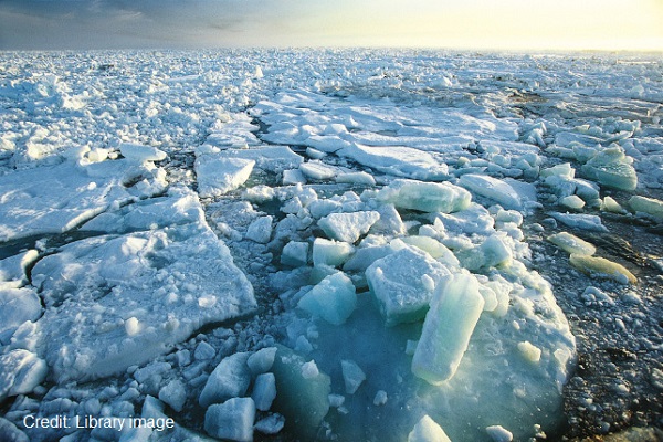
 Cryosat-1 is studying Earth’s sea ice. Every year the Arctic Ocean experiences the formation and then melting of vast amounts of ice that floats on the sea surface. This sea ice plays a central role in polar climate and the global ocean circulation pattern.
The Meteosat Third Generation (MTG) satellite programme will bring a step change in capability for operational meteorology. The programme will guarantee access to space-acquired meteorological data until, at least, the late 2030s. MTG will continue visible and infrared imagery and infrared and ultraviolet/near infrared sounding observations from geostationary orbit that will result in three-dimensional information on humidity, temperature, and wind to support Nowcasting.
The series will comprise six satellites: four MTG-I imaging and two MTG-S sounding satellites. The two types will be positioned over the same longitude in their geostationary orbits. The sounding element will also host the Copernicus Sentinel 4 air quality observatory. The first MTG satellites are planned to be launched around 2019/20.
The EUMETSAT Polar System (EPS) is Europe’s first polar-orbiting operational meteorological satellite system, and it is the European contribution to the Initial Joint Polar-orbiting Operational Satellite System (IJPS), a joint effort between EUMETSAT and NOAA. EUMETSAT’s polar-orbiting satellites (i.e. MetOp satellites) carry a set of state-of-the-art sounding and imaging instruments that offer improved atmospheric sounding capabilities to both meteorologists and climatologists.
The EPS Space Segment includes three successive Metop satellites and is being developed and procured in cooperation between ESA and EUMETSAT. Metop-A was launched in 2006 and Metop-B in September 2012. In April 2013, Metop-B replaced Metop-A as the EUMETSAT prime operational polar-orbiting satellite, following the end of its commissioning period. The combination of instruments onboard Metop satellites has remote sensing capabilities to observe the Earth during day- and night-time hours, as well as under cloudy conditions.
The follow-on EUMETSAT Polar System is now under way to replace the current satellite system in the 2020 timeframe and to contribute to the IJPS. Started in 2005 under the name of Post-EPS, the activities have been endorsed in 2012 under a new programme called MetOp Second Generation (MetOp-SG). Comprising six MetOp Second Generationsatellites in total, this programme is based on pairs of satellites that carry different packages to deliver complementary meteorological information.The A series of satellites will be equipped with atmospheric sounders as well as optical and infrared imagers, while the B series focuses on microwave sensors.In addition, the A series will carry the Copernicus Sentinel-5 instrument on behalf of the European Commission.Each satellite will be launched separately. It is envisaged that the first A satellite will be launched in 2021, followed by the first B satellite in 2022.
The Sentinel Missions
The Sentinels form the dedicated part of the Copernicus Space Component. Copernicus is the world’s most ambitious Earth observation programme. Copernicus is led by the European Union, with ESA being the coordinator of the space component. Copernicus is Europe’s answer to global needs, allowing us to manage the environment, to mitigate the effects of climate change and to ensure civil security.
The Sentinel missions, the first of which was launched in 2014, are based on a constellation of two satellites, each to provide robust datasets for operational services.
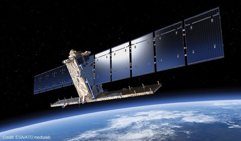
Sentinel-1: This polar-orbiting, all-weather, day-and-night mission will enable a SAR in C band supporting Copernicus operational services for land, marine, and risk management. The first satellite, Sentinel-1A, was launched in April 2014.
Sentinel-2: This is a polar-orbiting, multispectral high-resolution imaging mission for Copernicus land monitoring to provide imagery of vegetation, soil and water cover, inland waterways, and coastal areas. Sentinel-2 will also provide information for emergency services. The first satellite, Sentinel-2A, was launched in June 2015.
Sentinel-3: This mission is composed of two operational satellites with a one day (land) and a two day (ocean) revisit time. Each satellite will carry an Ocean and Land Colour Instrument (OLCI), a Sea and Land Surface Temperature Radiometer (SLSTR) and a microwave payload including a SAR Radar Altimeter (SRAL) and two frequencies microwave Radio Meter (MWR). This mission will support activities in the field of topography, sea and land surface temperature, ocean carbon, and land colour. The launch of the first satellite, Sentinel-3A is scheduled for fall 2015.
Sentinel-4: Planned for launch in 2019, this mission is a payload devoted to atmospheric monitoring that will be embarked on an MTG-S satellite. Ultraviolet and near infrared spectrometers will be used to continuously monitor air pollution and its precursors from North Africa to northern Europe at a 6 x 6 km2 spatial and one hour temporal resolutions.
Sentinel-5 Precursor is a polar sun-synchronous mission scheduled to launch in 2015 to reduce data gaps between Envisat and Sentinel-5 for global atmospheric composition measurements including ozone, aerosols and atmospheric pollution precursors. The instrument will be a follow-on to the Ozone Monitoring Instrument (OMI) flying on the NASA’s Aura satellite with additional channels in the near infrared.
Sentinel-5 is a payload that will monitor the atmosphere from polar orbit aboard a MetOp-SG A satellite projected to launch around 2021. It will continue the atmospheric composition data collected from Envisat and employ ultraviolet and infrared spectrometers that will the measure profiles and column amounts of trace gases and aerosols important in atmospheric chemistry and climate.
Growing field
ESA’s Earth science program has been steadily growing since the 1990’s. Distributing high-quality data and building on continuous technological progress driven by the computer and internet revolution, the ‘free & open” data policy has been the ultimate accelerator in guaranteeing the maximum exploitation of ESA data.
ESA also distributes satellite data from international partner agencies, so called Third Party Missions (TPM). The data from these missions are distributed under specific agreements with the owners or operators of those missions, which can be either public or private entities outside or within Europe.
… the mission responds to the pressing need for biomass observations in support of global treaties such as the United Nations Framework Convention on Climate Change initiative for the Reduction of Emissions due to Deforestation and Forest Degradation.
Collaborating with worldwide research organizations, operational space agencies, and international environmental groups is a top priority of ESA. We have conducted joint field campaigns for data validation with mission partners and have worked closely with international science teams for algorithm development, data homogeneity and accessibility.
The Earth Explorer missions are designed to address key scientific challenges identified by the science community while demonstrating breakthrough technology in observing techniques. ESA has also been EUMETSAT’s “agent” for the development of instruments, algorithms, and calibration/validation for their operational satellites.
Moreover, ESA is the coordinator for the space component of the Copernicus programme, which will kick off a new era of operational Earth observation, leaving the initial “pure science and technology” phase behind. With its suite of missions and programmes, ESA is well equipped to bring the benefits of space based Earth observation to citizens in Europe and worldwide.
References
1. FLEX includes three instruments to measure the interrelated features of fluorescence, hyperspectral reflectance, and canopy temperature.
2. CarbonSat will have a spatial resolution of 2 x 2 km2 and cover a 500 km wide swath.


