Earth observation data and information, collected from both space and ground platforms are the basis for addressing a multitude of environmental issues (see figure above). A globally co-ordinated strategy for the collection, integration and sharing of these data and information must, therefore, play an essential role in the context of the post-2015 Sustainable Development Goals (SDG) Agenda.
The Earth’s atmosphere, oceans and landscapes are being increasingly impacted by human activities. Monitoring and modeling these changes is critical for enabling governments and society to make informed decisions about water, energy, food security and any number of other global challenges facing humanity. Decision makers and program managers must have access to the environmental information they need, when they need it and in a format they can use.
GEO provides the framework for countries and international organisations to work together to link Earth observation systems
This translates into the vision that is the Group on Earth Observations (GEO): “… to realise a future wherein decisions and actions for the benefit of humankind are informed by co-ordinated, comprehensive and sustained Earth observations and information.”
GEO, established in 2005 with an initial set of 10-year targets, is a global partnership that provides the framework for countries and international organisations to work together to link Earth observation systems, to ensure worldwide access to the resulting data and information through broad, open data policies, to promote their use for decision-making, and to build capacity where needed.
More than 150 governments and leading international organisations are collaborating through GEO to build the Global Earth Observation System of Systems (GEOSS), and to promote its use as a global infrastructure for discovering and accessing Earth observation data and information.
GEO Members are ensuring access to GEOSS resources through a GEO Portal, providing an entry point to millions of Earth observation datasets, information products and services held by GEO Members and Participating Organisations.
These entities are also developing global initiatives that increase the impact of Earth observation data and information to societal decision making, by addressing identified user needs, harmonising methodologies, developing common technical standards, and by closing existing gaps in Earth observation data acquisition and information generation activities.
To date, the following global initiatives developed within GEO’s framework include, the Water Cycle Coordination Initiative (WCCI), Oceans and Society (The Blue Planet), the GEO Biodiversity Observing Network (GEO BON), the GEO Global Forest Observation Initiative (GFOI), the GEO Global Agricultural Monitoring (GEOGLAM) initiative, the Global Mercury Observation System (GMOS), and the Global Carbon Observing System (GeoCarbon).
The results of these initiatives comprise a knowledge base on the use of Earth observation data and information in support of decisionmaking at different geographical scales – global, regional, and national.
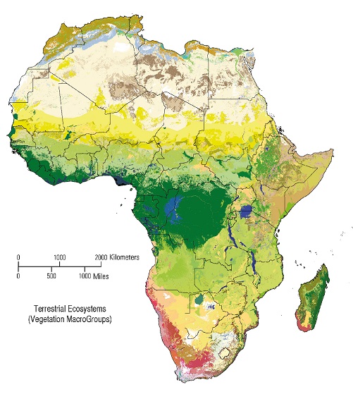
GEO Members are also undertaking Capacity Building initiatives to ensure that developing countries have the technical capability to take full advantage of GEOSS data and information, such as shown in a recently released map of terrestrial ecosystems of Africa, published by the Association of American Geographers (AAG) 2013 (see figure opposite).
GEO and the post-2015 SDG agenda
GEO’s founding principles are clearly aligned with the international, intergovernmental approach to developing the post-2015 SDG Agenda, and point to the need and opportunity for GEO’s proactive involvement in the development and implementation of the post- 2015 Agenda:
- A global partnership: GEO is a global partnership designed to address global environment observation and monitoring activities. The post MDG/SDG approach calls for global partnerships as one of the most critical ways to address global issues facing humanity.
- An integrated approach: A crosscutting, integrated approach, employed since its inception, GEO’s working principle has been to address issues of how the sustainable development agenda is being addressed. GEO’s result: a proven co-operation framework and worldwide network of expertise currently in place which delivers results.
- A geographic focus from global to local: GEO’s initiatives are multi-scale. While there is co-ordination and implementation at the global level, GEO’s programmes are also implemented regionally, nationally and locally – the same objective around which the post-2015 SDGs are being consolidated.
- A consistent timeframe: GEO is nearing the end of its first decade. Development of its objectives and activities for a second decade, up to 2025, is underway. A GEO Ministerial Summit, planned for January 2014 in Geneva, Switzerland, has as an expected outcome the confirmation that GEO has advanced global Earth observations, and that it should be continued to 2025 with a mandate to develop a new Implementation Plan, which will take full account of the post-2015 Agenda and SDG process.
 Source: Association of American Geographers (AAG) 2013
Earth observations, and that it should be continued to 2025 with a mandate to develop a new Implementation Plan, which will take full account of the post-2015 Agenda and SDG process.
A unique opportunity for co-operation
GEO has demonstrated its capability to develop and augment global initiatives that improve the contribution of Earth observation data and information to societal decision making, by addressing user needs and by closing gaps in Earth observation data acquisition and information generation activities. The renewal of its mandate after 2015 will solidify Members’ contributions to enable global leaders to address major environmental challenges flexibly and rapidly, thereby advancing global environmental governance.
The Rio+20 Conference affirmed the three interdependent and mutually reinforcing pillars of sustainable development – economic development, social development and environmental protection. The Conference also recognised the importance of space-based data, in situ monitoring and reliable geospatial information for sustainable development policy making, and fully acknowledged GEO’s efforts in developing GEOSS to address sustainable development goals.
GEO is prepared to be a key partner in developing the post-2015 SDG Agenda and supporting its implementation by ensuring access to essential environmental data and information.
Timely inclusion of GEO in the process defining the post-2015 Agenda and SDGs is an important step toward properly addressing the global challenges facing humanity. GEO stands ready to contribute its assets to this vitally important effort.


