


The answer from the People’s Republic of China (PRC) to the political visit of US House Speaker Nancy Pelosi and a Democratic congressional delegation to Taiwan in August 2022 was pretty much as expected. It came in the form of threatening military operations and drills executed against Taiwan, with manoeuvres taking place in the waters and skies near Taiwan and including the live-firing of ballistic missiles in the Taiwan Strait.
Undoubtedly, the use of the formidable Chinese satellite remote sensing assets made clear to the American military involved, that the ability to deploy warships or aircraft with impunity, and even to operate safely from bases in the region, was no longer the case as it was during the mid-1990s.
At that time a crisis erupted over Taiwan’s president visiting the US, prompting an angry reaction from Beijing. Reacting, the US Navy sent warships through the Taiwan Strait and there was nothing the PRC could do about it. Now, the USS Ronald Reagan aircraft carrier group just remained in the region to “monitor the situation”. The greatly improved Chinese satellite surveillance capabilities and inherent intelligence of the last two decades made the difference for the most part.
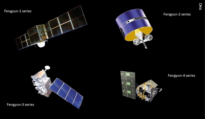 Four types of Fengyun meteorological satellites.
This article provides an overview of the development and current execution of China’s civil satellite surveillance capabilities. From 2015 on, commercial satellite Earth observation plays an important role too. Since remote sensing (data) from satellites is dual-use, there is no clear distinction between civil and military satellite surveillance, but for the sake of clarity it will be maintained. Only satellites are covered, ground application systems and infrastructure are not considered.
CIVIL REMOTE SENSING
Fengyun (FY) meteorological satellite
Fengyun is a meteorological satellite series managed by the China Meteorological Administration. Within the meteorological programME, the odd-numbered satellites (FY 1, FY 3) refer to polar orbiting low Earth orbit (LEO) satellites, while the even-numbered satellites are geostationary Earth orbit (GEO) satellites (FY 2, FY 4).
The FY 1 satellite series was China’s first generation of polar-orbiting meteorological satellites. Its main task was to obtain atmospheric, cloud, land and ocean information at home and abroad, and to collect relevant data for weather forecasting, climate prediction, natural disasters and global environmental monitoring.
FY 1 and FY 2 started and improved China’s weather forecast capabilities over time. Second generation satellites became operational in 2008 (LEO FY 3) and 2016 (GEO FY 4). Fengyun satellite data products are available to users all over the world and can be downloaded for free. Fengyun satellites are included in the world’s global operational meteorological satellite series of the World Meteorological Organization.
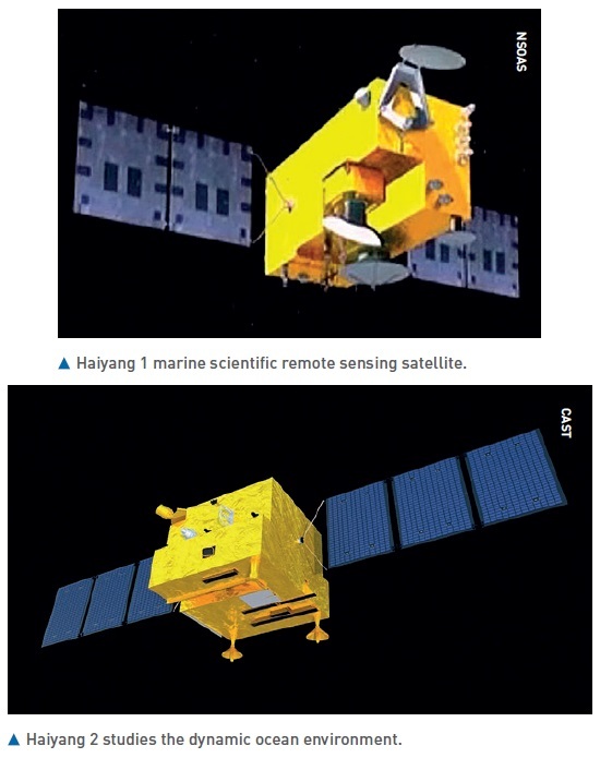
Haiyang (HY) ocean satellite
Haiyang are a group of marine scientific remote sensing satellites developed by the Chinese Academy of Space Technology (CAST) and operated by the National Satellite Ocean Application Service, a subordinate agency of the State Oceanic Administration. The spacecraft use the three-axis stabilised CAST968 platform.
CASTChina plans to launch a total of 11 Huanjing satellites for disaster and environmental monitoring with visible, infrared and multi-spectral sensors, and synthetic-aperture radar
The HY 1 series [2002, 2007, 2018 & 2020] is China’s first satellite for surveying ocean resources (ocean colour and sea surface temperature) and monitoring the environment.
The HY 2 series [2011, 2018, 2020 & 2021], is a parallel series to HY 1. HY 2 monitors the dynamic ocean environment with microwave sensors. It detects sea surface wind field, sea surface height and sea surface temperature. Sensors are an altimeter, a scatterometer and a microwave imager.
HY 3 satellites, still to be launched, will be used to monitor islands, coastal zones, and maritime targets to obtain ocean geodesy information with optical, infrared and microwave sensors
 Huanjing 1 disaster and environmental monitoring satellite.
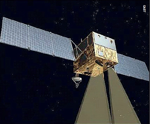
Huanjing (HJ) disaster and environmental monitoring satellite
China plans to launch a total of 11 Huanjing satellites which will be used for disaster and environmental monitoring. All of these satellites will have visible, infrared and multi-spectral sensors, as well as synthetic-aperture radar (SAR) and, to date, five spacecraft in the series have been launched.
The first two satellites, HJ 1A/B, were launched simultaneously in 2008 in a coplanar orbit with a phasing of 180 degrees and were optical imaging satellites. HJ 1C, that was launched in 2012, is the first civilian Chinese remote sensing satellite to use SAR radar. This S-band SAR was manufactured in Russia by NPO Mashinostroyeniya. In 2020, HJ 2A/B were launched and probably are improved satellites that will replace HJ 1A/B.
Ziyuan/CBERS (ZY) Earth resources satellite
The Ziyuan I/CBERS programme integrated a 1970s plan to develop Brazilian and Chinese economies through major projects by promoting the use of space. Ziyuan I/CBERS satellites were designed for global coverage and include optical cameras and a system for collecting data on the environment. They are jointly managed by the PRC and Brazil. From 1999 to 2019, four successful CBERS missions were flown; three more ZY missions were launched in which China did not cooperate with Brazil.
Ziyuan II was billed as a civilian Earth observation system, but was militarily codenamed Jianbing-3 and was China’s first [2000] military high-resolution, digital, remote sensing satellite.
Ziyuan III is China’s first high-resolution civilian stereoscopic Earth observation programme and has the overall goal of creating large-scale, three-dimensional maps and “providing relevant parameters for environmental monitoring, resource management, disaster response, urban planning and national security”.
China High-resolution Earth Observation System (CHEOS)
In 2006, CHEOS was established as one of 16 major national science and technology projects. It was proposed to build a high-resolution Earth observation system based on satellites, stratospheric airships and aircraft. The associated ground systems would be improved or developed.
The combination of these measures had to provide an all-weather, all-time, and global Earth observation capability. CHEOS therefore, should have multi-observation capabilities to provide high spatial-, temporal- and spectral resolution properties. From 2013 on, Gaofen satellites were launched to create the satellite based part of CHEOS.
Gaofen high resolution Earth observation satellite (GF)
For the CHEOS programme, more than 25 Gaofen satellites have been launched since 2013. These satellites are based on CAST satellite buses.
It is known from the first seven GF series that different sensors are often used on each satellite. For example, GF 1, 2, 4 and 6 have high-resolution cameras and GF 3 is equipped with a C-band SAR. GF 5 has six sensors, including a hyper spectral camera and a directional polarisation camera. The extra laser altimeter system on GF7 enables three-dimensional research. Resolution capabilities and other information about Gaofen satellites was published for the lower numbered Gaofen series of satellites. Information for Gaofen satellites with number 8 and higher has not been publicly released, suggesting that the satellites are (partly) for national defence purposes.
COMMERCIAL REMOTE SENSING
Beijing series of satellites
This series of commercial optical remote sensing satellites - Beijing 1 [2005] and the TrippleSat constellation Beijing 2 [2015] - was commercially built for China by Surrey Satellite Technology in the UK. Noteworthy, is that the imaging capacity of Beijing 2 was 100 percent leased by a Singapore based company.
Beijing 3 [2021, 2022] satellites have been built by China Aerospace Science and Technology Corporation to acquire optical remote sensing satellite data and information products for the global commercial market. Beijing 3 satellites will mainly be used to provide remote sensing services in the fields of land resources management, agricultural resources survey, environment monitoring and city applications.
Jilin-1 series of satellites
Boosted by policy support, China’s aerospace market has reportedly grown rapidly in the past seven years
Jilin-1 is China’s first, self-developed, commercial remote sensing satellite system and is operated by the Chang Guang Satellite Technology Corporation (CGSTC). The Jilin-1 satellite constellation is the core project and will eventually be composed of 138 remote sensing satellites covering high resolution, large swath width, video and multi-spectrum, and a high revisit commercial service. By August 2022, CGSTC had successfully launched some 65 Jilin-1 satellites into space.
The completed Jilin-1 constellation will be able to visit any place in the world 15 to 17 times per day, with the ability to update a global map every year and a national map five times per year. It can provide “high-quality remote sensing information and product services for agricultural and forestry production, environmental monitoring, smart city, geographical mapping, land planning and other fields”.
The first generation of Jilin-1 satellites were put in orbit in 2015, the second generation in 2019. A batch of eight Jilin-1 satellites (one Wideband 01C and seven Gaofen 03D spacecraft) were put in orbit on 5 May 2022.
The Wideband 01C Kuanfu-01C satellite is a 230 kg spacecraft featuring a high resolution video capability. The payload provides a 0.5 m resolution optical as well as a 2 m resolution multi-spectral capability. The seven 40 kg Gaofen 03D high-resolution imaging satellites in this launch provide better than a 0.75 m resolution optical as well as a 2 m resolution multi-spectral capability.
The last batch, 10 August 2022, consisted of 16 Jilin-1 imaging satellites including 10 in the Jilin-1 Gaofen high resolution optical imaging series, and the first six in the Jilin-1 Hongwai A (infrared imaging) series.
Comprehensive information on Jilin-1 satellites can be obtained from the CGSTC website at http://www.jl1.cn/EWeb/product2.aspx?id=23
Boosted by policy support, China’s aerospace market has reportedly grown rapidly in the past seven years, with an annual growth rate of more than 20 percent, making China the world’s second largest commercial satellite owner after the United States.
According to the Union of Concerned Scientists Satellite Database (from 2015 to 2018), China launched fewer than 10 commercial remote sensing satellites annually but the introduction of support policies helped commercial players.
Between 2019 and 2021, the annual commercial remote sensing satellites that were launched were 21, 13 and 36 respectively, while the number by the end of 2022 is expected to be more than 50.
About the author
Henk Smid is retired chief officer of the Royal Netherlands Air Force, space analyst and publicist of numerous space related articles (https://smid.one). He has been an advisor to several national and international working groups on space-related topics for which he has prepared/written a series of analyses and projections [Defence, NATO, European Commission]. Henk Smid gives lectures on space systems and technologies.