


The unique, open geography of the Middle East combined with the rapid dissemination of technologies such as high-resolution Earth observation satellites, unmanned aerial vehicles, mobile devices such as smart phones, social media, and the emergence of big data and artificial intelligence are causing a dramatic change in the character of war and diplomacy.
This change offers Middle East governments and others in and out of the region opportunities to enhance their national security - but at the same time can also restrict their ability to act in secrecy, or at least it will change expectations of how long such actions will remain secret.
A growing number of countries throughout the region are acquiring high-resolution Earth observation satellites, from Algeria and Morocco via Egypt and Turkey, through to Iran, Saudi Arabia, and the United Arab Emirates. This trend is a dramatic change in the Middle East region where only 10 years ago the only country that had such advanced technology was Israel, along with external powers such as the United States, France, and Russia.
On top of the growing number of Middle East countries acquiring highresolution Earth observation satellites, there is a disruptive commercial phenomenon in satellite imagery also underway
On top of the growing number of Middle East countries acquiring high-resolution Earth observation satellites, there is a disruptive commercial phenomenon in satellite imagery also underway. Companies such as DigitalGlobe, based in the United States, and Europe’s Airbus Defence and Space have been providing Middle East clients with high-resolution satellite imagery for many years now, but their business model has been upended by the rise of companies like Planet Labs, Terra Bella, UrtheCast, BlackSky and others that are building constellations of hundreds of very small Earth observation satellites that will provide almost ubiquitous, real-time coverage of the Earth at cut-rate prices.
This means that high-resolution satellite imagery will become increasingly available to not only governments and large corporations in the Middle East, but also to individuals and small organisations – including criminal organisations and terrorist groups.
‘Spacepower’ is the ability in peace, crisis and war to exert influence in, to and from space, and until now has been something that only less than a dozen or so powerful countries – the United States, Russia, China, India, Japan, France and several others – have been able to use.
With the dissemination of high-resolution Earth observation satellites, as well as ubiquitous commercial access thanks to Planet Labs and others, more and more countries in the Middle East – and around the world – are now finding that spacepower is also within their reach. Furthermore, this technological dissemination will combine with the Middle East’s unique strategic geography to create a paradoxical situation for the use of military power and the conduct of geopolitics within the region.
Open geography
According to American strategists Geoffrey Kemp and Robert E. Harkavy, spacepower - as a set of satellite technologies - “has great advantages in the open desert terrain in which most Middle East wars have been fought.” While the geography of the Middle East is far from homogeneous, it is predominantly composed of vast and open desert from western North Africa through much of the Arabian Peninsula and much of Iran. The exceptions to this predominant geographical feature include various mountain ranges such as the Taurus Mountains in Turkey and the Zagros Mountains, along which lies the border between Iran and Iraq. Further, there are places such as the Nile Delta, a fertile and highly urban part of the Middle East, and the so-called Fertile Crescent that ranges from the banks of the Nile River through the coastline of the Eastern Mediterranean through Syria and Iraq.
‘Spacepower’ is the ability in peace, crisis and war to exert influence in, to and from space
Over centuries human beings in the Middle East have also altered the geography of the region through irrigation and other agricultural developments, as well as through growing urbanisation throughout North Africa, the Arabian Peninsula and Iran. Cities like Cairo, Egypt and Tehran, Iran have urban populations of up to 17 million people. Additionally, older cities in the Middle East, such as Cairo and Damascus, are densely built and populated.
For the most part, this open terrain throughout the region is highly advantageous to the use of spacepower, allowing the data links from communications and navigation satellites unfettered access to users, and Earth observation satellites clear views of the region, aided by generally favourable weather conditions for most of the year.
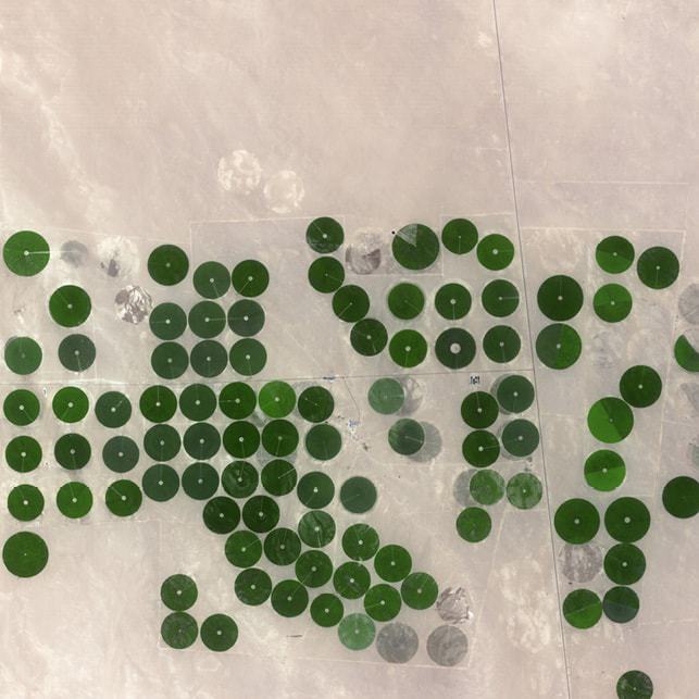 Regimented areas of agricultural cultivation, known as centre-pivot irrigation, in Haradh, Saudi Arabia, in a 2.5 m resolution optical image by the SPOT 5 satellite.
It is only in mountainous and densely populated urban areas that restrictions are imposed on the use of spacepower. Steep valleys and narrow, over-built streets with tall buildings, limit the effectiveness of communications and navigation satellite coverage. Earth observation satellites can certainly map these particular regions, but long shadows caused by mountains and buildings can also limit their intelligence effectiveness.
Strategic depth
The strategic geography of the Middle East combines with the strategic attributes of spacepower to create an ideal region for the use and application of satellites. These strategic attributes of spacepower include perspective, access, presence and strategic depth - and they make spacepower a unique form of power for anyone able to wield it, though that power is exponentially enhanced when combined with diplomatic, economic and traditional military power (land, sea and air power).
The spacepower attribute of perspective allows satellites in orbit above Earth’s surface, from several hundred kilometres to 36,000 km in geostationary orbit, coverage over great distances within and beyond national boundaries. Perspective, also known in military parlance as the ‘high ground’, comes from the wider view of Earth’s surface provided by satellites.
From perspective comes the strategic attribute of access, where orbital mechanics, Earth’s natural rotation on its axis, and the international legal regime provided by the 1967 Outer Space Treaty (OST), allows satellites to gather data from, and communicate into, areas of the planet that are either politically or naturally inaccessible.
For example, the international community has relied heavily on high-resolution Earth observation satellites to monitor the nuclear and ballistic missile activities of the closed society of North Korea. Similarly, environmental monitoring satellites allow users to monitor the impact of climate change in generally inhospitable regions such as the Arctic and Antarctic.
From access flows the strategic attribute of presence, where satellites are the first assets on ‘the scene’, especially in natural disasters such as earthquakes or tsunamis. Similarly, satellites in various orbits are always present over, or at least provide regular coverage of, Earth’s surface. For example, the Iranian and North Korean nuclear programmes have been forced literally underground because of the persistent presence of reconnaissance satellites. While these satellites have not stopped these countries from pursuing their nuclear ambitions, they have imposed significant time and financial penalties on Tehran and Pyongyang.
Lastly, the attributes of perspective, access and presence all combine to create the fourth, and perhaps most significant, strategic attribute of spacepower: strategic depth. This combination creates a vertical flank perpendicular to Earth’s surface that provides horizontal operational and strategic depth for the spacepower user. Strategic depth allows the spacepower user to trade physical space for time because it is able to detect events, movements and threats long before they impact the user’s own interests, assets or forces. For example, Israel has mastered spacepower in order to attain the strategic depth it lacks on Earth’s surface. Israeli spacepower operates well beyond Israeli borders and so contributes to Israeli deterrence of conventional military threats.
It is becoming increasingly difficult for governments and other powerful actors to operate without being subjected to public and international scrutiny
In addition to these strategic attributes are spacepower’s technical attributes of versatility, ubiquity and continuity. Spacepower is versatile because satellites can be used simultaneously for a variety of purposes. For example, satellite navigation systems can be used to provide precision targeting for militaries, navigation for automobile drivers and timing for financial networks and cellular telephone networks around the world - all simultaneously.
Spacepower is ubiquitous, or in the case of Earth observation near ubiquity, because communications, satellite navigation and environmental monitoring satellite systems provide coverage of the entire Earth’s surface.
Finally, spacepower provides continuity because satellites are always operating 24 hours a day, seven days a week and 365 days a year over operational lifetimes per satellite that can exceed 15 years.
As a growing number of Middle East countries acquire satellites they are able to take advantage of these strategic and technical attributes of spacepower, provided they can integrate it into their diplomatic, economic and military power. Integration is the most challenging aspect of deriving true strategic advantage from satellites.
Rising transparency
Another challenge, however, is the rise of transparency created by disseminating satellite technology, as well as mobile cellular and computer devices, social media, and big data and artificial intelligence.
Scholars and policy makers have acknowledged that the conduct of foreign and defence policy is becoming more challenging because in recent decades it has had to be conducted in the public glare because the media has increasingly been able to broadcast events as they happen, and the growing number of ordinary members of the public in possession of phones with cameras. This has meant it has become more difficult to operate clandestinely, and even if clandestine operations can be conducted the risk that they can be revealed in a short period of time has increased exponentially.
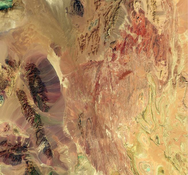
 A false colour satellite image of central Iran taken by the Operational Land Imager (OLI) on Landsat 8 which collects information in 11 narrow bands of wavelengths on the electromagnetic spectrum. False-colour imagery is used to provide additional scientific insights - the near infrared (band 5) in this image can be helpful for understanding vegetation and ecology because healthy plants reflect near-infrared light and the shortwave infrared (band 6) makes it easier to tell the difference between wet and dry areas. The false colour image, centred near the border of the Yazd and South Khorosan provinces of Iran, makes it easier to pick out boundaries between different rock layers and formations. It is also possible to see where water flows down from the dark ridges on the western edge. The streaks of green show the distribution of rock with a particular composition rather than vegetation.
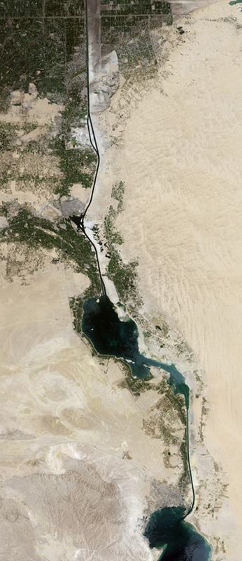
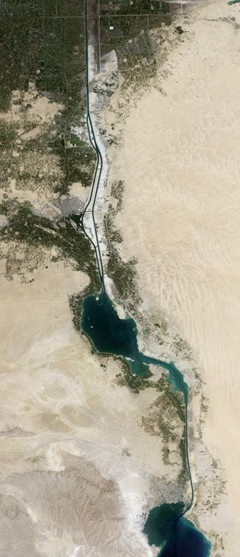 The Suez Canal - the first artificial waterway connecting the Mediterranean Sea and the Red Sea - initially opened in November 1869 after 10 years of construction. The ‘new’ Suez Canal shown in the second image opened in 2015 after just one year of construction. The Operational Land Imager (OLI) on the Landsat 8 satellite acquired these images of the canal’s mid-section, where the expansion project was focused. The left image was taken in August 2014 and the right image in April 2016. The older single-lane canal, including the north and south access channels, spans 193 km from Port Said on the Mediterranean Sea to the Port of Suez on the Red Sea.
Today, this transparency trend has sped up exponentially thanks to both the growth of the trends described above and also the emergence of new trends such as easily accessible satellite imagery, the viral potential of social media such as Twitter and Facebook, the ubiquity of mobile devices (the number of which now outnumber the world’s entire population), and the potential revealed by big data and artificial intelligence that can gather and sift through all of this data in very short periods of time.
With the exception of North Korea, no country has been exempt from these technological trends. When American special forces raided the compound used by Osama bin Laden in Abbottabad, Pakistan, in 2011 the world was alerted to it because a nearby resident Tweeted about the commotion underway.
Similarly, the world – including heads of state and their intelligence services – has been made aware of the horrors perpetuated by Bashar al-Assad’s forces and Daesh in Syria because of noncombatants communicating events in real time through mobile devices and social media. In the case of Daesh, their sophisticated use of these new technologies has been used to deliberately communicate atrocities to a horrified and outraged global public.
In particular, the continuing dissemination of high-resolution Earth observation satellites, as well as the revolutionary changes in satellite imagery brought about by commercial companies like Planet Labs and Terra Bella, are an integral part of this trend toward transparency. In the Middle East alone, high-resolution Earth observation satellites are on the verge of rapid dissemination. Algeria, Egypt, Iran, Israel, Morocco, Saudi Arabia, Turkey and the United Arab Emirates either already own such capabilities, or will have them in operation in the next couple of years.
Furthermore, many Middle East countries purchase high-resolution satellite imagery from American, French, and Russian companies for everything from military operations through to urban planning. Now, with companies like Urthecast and BlackSky operating and launching hundreds of small satellites, high-resolution satellite images can be purchased for as little as US$100 an image (compared to the thousands of dollars per image charged by companies like America’s DigitalGlobe). This makes satellite imagery available not only to Middle East governments and large companies like Aramco but also to small businesses and even terrorist groups such as Daesh.
The biggest implication, however, is that this radical technological change combines with a strategic geography of mostly open terrain to create the perfect conditions for transparency. Add to this the wider technological and cultural impact of mobile devices and social media in the Middle East, and it becomes increasingly difficult for governments and other powerful actors to operate without being subjected to public and international scrutiny.
Spacepower paradox
All of this leads to the paradox of spacepower in the Middle East. On one hand regional governments are acquiring a powerful technology that can take advantage of open terrain and enhance the national security of its users by potentially expanding their strategic depth and deterring conventional conflict.
On the other hand, this same powerful technology, combined with mobile cellular and computer devices, social media, big data and artificial intelligence, will probably restrain the strategic options of these same governments because nearly everything they do – especially in the realm of national security – will be subject to public and international attention.
There will be those, of course, who will not be constrained by the pitfalls of transparency, such as the current Syrian government and Daesh. Others will be more circumspect, however, in how they use military force, for fear that their aims and purposes might be frustrated before they even have a chance of success. More likely, the rise of transparency will make the character of war in the region change even further by placing a premium on the use of special forces and cyber warfare. Even then, however, Middle East governments should not expect the use of these clandestine tools to stay secret for long.
Global transparency
For decades the strategic geography of the Middle East has been the backdrop for radical changes in the character of war. These changes have become the victim of their own success as Israeli and US conventional military superiority has forced their opponents to seek more clandestine and asymmetric military responses that have now become commonplace throughout the Middle East and beyond.
Highresolution Earth observation satellites and other technologies are creating a more granular type of global transparency
Technology has caught up with all strategic actors in the region. Whether it’s a country like Saudi Arabia that possesses the most up-to-date and advanced military equipment or the likes of Daesh or Hezbollah that rely on more unconventional military approaches, the combination of disseminating high-resolution Earth observation satellites and other technologies is creating a more granular type of global transparency, and at the same time a paradox for decision-makers in the region.
Transparency brought about by high-resolution Earth observation satellites and other technologies will be the cause of further change in the character of warfare and diplomacy in the Middle East for many years to come. It will not change the nature of war or the fundamentals of international competition - but their conduct will change irrevocably.