 May 2018
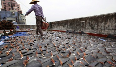
Satellite data helps combat illegal shark fishing
May 2018
Satellite data helps combat illegal shark fishing
..., it is now possible to track and monitor worldwide vessel behaviour that may be putting marine reserves at risk. Satellite imagery, geospatial technology and big data are used to spot, identify and investigate abnormal or potentially illegal fishing...
 August 2021
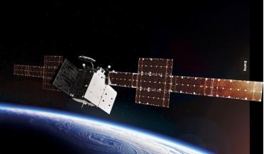
AI in space – a legal perspective
August 2021
AI in space – a legal perspective
... contemporary ethics. One can foresee real-time interpretation of satellite imagery by deep learning algorithms, or even by intelligent satellites able to observe and analyse imagery ‘on the fly’. In addition to the possibilities that AI presents for...
 October 2025
Satellite technology - from operational challenges to strategic opportunities
October 2025
Satellite technology - from operational challenges to strategic opportunities
... remote sensing capabilities. As with satcoms, commercial Earth observation providers are democratising access to satellite imagery and analytics, enabling new applications across agriculture, environmental monitoring, insurance and urban planning...
 November 2019
Mexico’s path to space
November 2019
Mexico’s path to space
... communications. The other, in the State of Mexico, will develop small satellites, and will specialise in rocket design and provide data processing services on satellite imagery. These centres will operate in partnership with state governments and...
 July 2020
Covid-19 infects global space community
July 2020
Covid-19 infects global space community
... Labs, Mapbox, Orbital Insight, SpaceKnow and Ursa) are seeing a growing interest from customers seeking to use satellite imagery to track the spread of COVID-19. Data is being used to monitor critical infrastructure and assess economic impact...
 March 2021
Data may be the new oil... but its real value is in actionable information
March 2021
Data may be the new oil... but its real value is in actionable information
... acreage and yield estimates could be obtained from satellite imagery. However, the methods for environmental monitoring improved ..., the Land Cover Map 2000, a project that used satellite imagery, took more than three years to acquire a suitable EO...