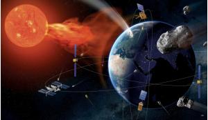


The United States military is currently undergoing a notable transformation in its intelligence-gathering capabilities. The US armed forces plans to shift their focus from conventional aircraft to space-based assets, embracing commercial Earth observation on a larger scale. Clint Graumann takes a commercial overview of some of the factors driving this new strategy.
The US military’s decision to switch to space-based intelligence-gathering was recently disclosed in a report by national security outlet Defense One, featuring insights from General Mark Kelly, the head of Air Combat Command. The report highlighted the potential advantages that space-based assets could offer in enhancing intelligence, surveillance and reconnaissance (ISR) capabilities.
In the General’s own words, “The force elements that we must send forward to [deploy] today, I’d highly recommend we have a discussion, as an entire force, to put in space tomorrow.” Driving factors behind Kelly’s desire include the high costs and vulnerabilities associated with traditional aircraft and their dependency on extensive support crews. Consequently, it signifies a fundamental shift toward embracing satellite technology as the future of intelligence-gathering. Free-flying satellite technology stands out as a pivotal development, poised to become the next frontier in Earth observation.
The move from aerial remote sensing to space-based Earth observation has demonstrated significant success in other aspects of Earth monitoring. An illustrative case of this transformation is the shift from the traditional reliance on aerial-based optical imagery and synthetic aperture radar (SAR) collection to the adoption of space-based methodologies. This evolution finds its roots in the continuous advancements in satellite technology and the growing accessibility of cost-effective launch alternatives, underscoring the pace and depth of progress in this field.
Conventional remote sensing methods relying on aircraft have struggled with various limitations, including issues related to scalability, elevated operating costs and susceptibility to geopolitical constraints. In stark contrast, satellites have the capacity to cover vast geographical areas, making global monitoring a reality. Furthermore, satellites can efficiently gather data from remote or challenging terrains, such as the Arctic or conflict zones, which are typically inaccessible or highly challenging for aircraft-based platforms.
Following years of development by space agencies around the world, the transition to space-based Earth observation was further facilitated by private companies that have developed high-resolution imaging satellites at substantially lower costs and with greater agility than government efforts. Companies like RapidEye reduced costs and improved scalability by introducing the first commercial constellation approach to Earth observation. In the SAR domain, companies such as Infoterra and Capella Space have played a pivotal role in enabling its successful transition to space-based platforms.
These space-based assets have paved the way for extensive applications in both the commercial and governmental sectors, ranging from military reconnaissance to global climate monitoring. They have effectively demonstrated a viable model of data transfer from ground to air, from air to government (space) and from government space to commercial space-based applications. Nonetheless, an important piece of the puzzle remains missing: the implementation of space-based LiDAR collection.
Light technology
The move from aerial remote sensing to space-based Earth observation has demonstrated significant success in other aspects of Earth monitoring
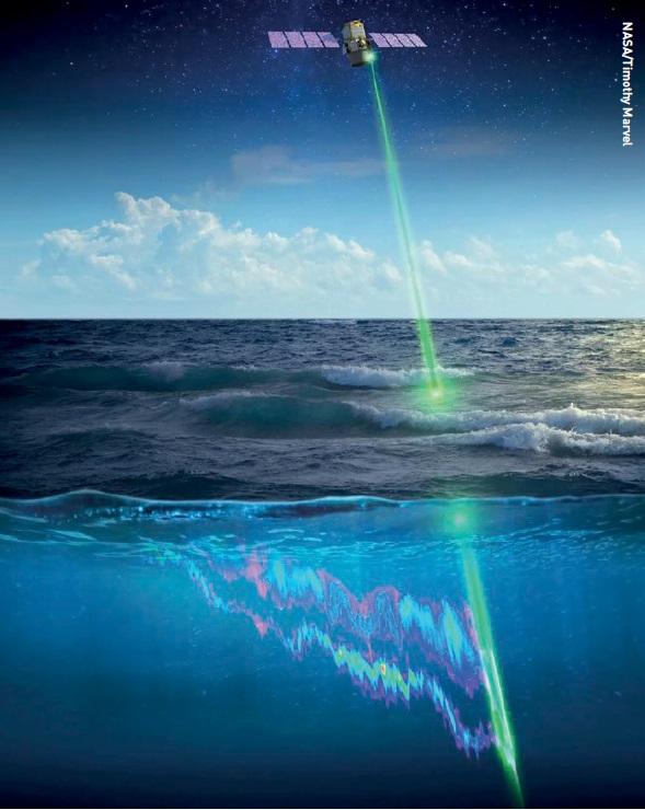
Light detection and ranging (LiDAR) offers a unique advantage in that it enables remote sensing by actively illuminating the Earth’s surface instead of relying upon the light from the sun. In essence, LiDAR is a light-based version of synthetic aperture radar, which itself uses the radio-frequency part of the electromagnetic spectrum.
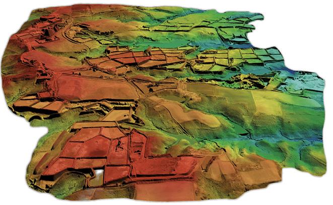
Historically, LiDAR technology has been employed on aircraft or ground-based platforms, using laser pulses to measure distances with extreme precision. This approach creates detailed, real-time, three-dimensional maps. Unlike standard optical imaging, LiDAR can operate in low-light conditions and has the ability to penetrate foliage, such as forest canopies, to reveal hidden details. As a result, LiDAR is indispensable for applications such as flood modelling, environmental monitoring and intelligence gathering.
 LiDAR facilitates precise mapping of terrain and infrastructure, providing critical data for efficient network planning, optimisation and maintenance for improved connectivity.
LiDAR arguably offers the highest value of all remotely sensed data sets and the potential benefits of space-based LiDAR mapping are extensive. Not only does it offer global coverage compared to the regional or local reach of aircraft-based systems, but it can also provide more accurate and nuanced elevation data in remote or challenging terrains. This capability enriches our understanding of the Earth’s topography and natural processes, presenting opportunities to revolutionise disaster response through the provision of real-time 3D maps for rescue operations. It also enhances environmental monitoring by enabling more precise models of forest density and plant health.
An example is provided by the 3D Nation Elevation Requirements and Benefits Study, conducted by Dewberry Engineers and sponsored by the National Oceanic and Atmospheric Administration (NOAA) and the US Geological Survey (USGS). This extensive study, which engaged 45 federal agencies, 56 states and territories and 58 non-governmental organisations, assessed the need for improved topographic and bathymetric elevation data across the United States. The comprehensive report, released in September 2022, spanned over 14,000 pages and addressed specific user requirements for inland topography, inland bathymetry, and nearshore and offshore bathymetry. Its findings revealed the potential for annual benefits amounting to US$13.5 billion, upon full implementation of an enhanced national elevation programme.
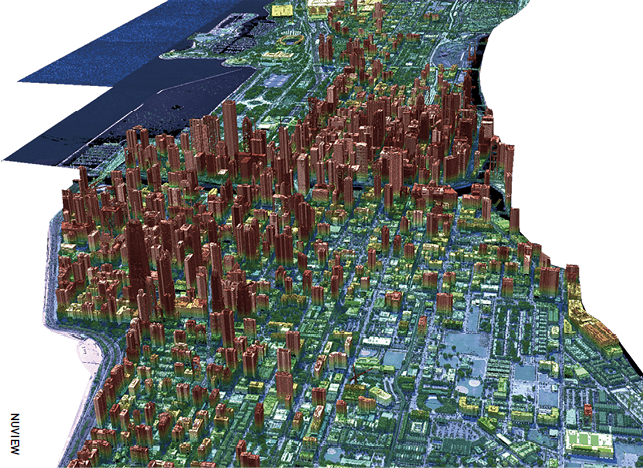
 NUVIEWLiDAR technology is crucial for supporting national mapping programmes in civil governments, providing high-resolution, accurate data across various applications, including: Base Mapping, Infrastructure Planning and Development, Land Use and Zoning, Emergency Management and Disaster Response, Geospatial Intelligence, Property Valuation and Environmental Management.
One of the most intriguing aspects of this transition to space-based LiDAR is its potential to facilitate machine learning and artificial intelligence (AI) technologies. Traditional LiDAR datasets, while detailed, often suffer from limitations related to scope and application due to the high costs and operational complexity of aircraft-based data collection. This data is further constrained by weather conditions and logistical challenges related to deploying pilots for data collection. Space-based LiDAR data, on the other hand, can be integrated into AI algorithms on an unprecedented scale, providing a more extensive and diverse training dataset. The value of LiDAR data for AI and machine learning is unparalleled, as it offers billions of data points with discrete values, eliminating the need for estimations and delivering precise, native 3D measurements.
Future promise
The commercial implications of space-based LiDAR are also highly promising. As it is integrated into various sectors from real estate to energy, space-based LiDAR is poised to become the new horizon of revenue generation in Earth observation.
For instance, AI-powered analytics services can offer businesses valuable insights for optimising logistical routes, assessing land values or identifying ideal locations for renewable energy installations - opportunities that would be unattainable with aerial applications alone. With aircraft you can’t collect it; and if you can’t collect it, you can’t measure it.
Despite the bright prospects, current terrestrial LiDAR methods face substantial limitations. High costs, inefficiencies and limited geographical reach of aerial-based systems frequently hinder scalability and broad application. Moreover, data processing and analysis can be resource-intensive, further exacerbating operational costs.
LiDAR can operate in low-light conditions and has the ability to penetrate foliage, such as forest canopies, to reveal hidden details
However, space-based LiDAR technology holds the promise of surmounting these constraints. Through the uninterrupted flow of data facilitated by a worldwide satellite network, the potential for scalable, cost-effective applications of LiDAR technology emerges as a tangible and groundbreaking prospect. The continuous stream of LiDAR data from satellites provides a transformative solution to the challenges previously faced, offering unprecedented opportunities for a diverse range of sectors and industries. This innovative approach unlocks new avenues for precision and efficiency in data collection and analysis, revolutionising the way we perceive and interact with our surroundings.
Researchers used NASA’s space-based CALIPSO LiDAR over 17 years to measure Earth’s largest animal migration, which takes place when small sea creatures swim up from the depths at night to feed on phytoplankton, then back down again just before sunrise.
The transition from aerial to space-based platforms for optical imagery collection has already showcased the transformative impact that such a shift can have on multiple industries and global initiatives. LiDAR is poised to follow a similar trajectory to optical and SAR technologies, heralding a new era in Earth observation, one that fully harnesses the capabilities of modern technology, artificial intelligence and scalable revenue models.
Embracing space-based LiDAR technology represents a pivotal step towards attaining global sustainability objectives, fostering scientific progress, and opening doors to financially rewarding commercial ventures. This paradigm shift in Earth observation expands the scope of what is achievable, fundamentally altering our approach to environmental stewardship.
By adopting space-based LiDAR, we embark on a journey that transcends mere observation - we gain the capacity to comprehend our world in previously unimaginable ways. The amalgamation of space-based LiDAR and cutting-edge AI technologies stands as the linchpin for a future characterised by heightened knowledge, enhanced sustainability and greater fairness. This synergy empowers us to make informed decisions, ensure the responsible utilisation of resources, and promote an equitable and sustainable future for all.
About the author
Clint Graumann is the Co-Founder and CEO of NUVIEW, Inc, a pioneering geospatial technology company at the forefront of the Earth observation industry. He leads the vision, strategy and execution of all aspects of the company, bringing his experience and passion for remote sensing to the fore. NUVIEW harnesses geospatial technology to drive innovation and provides cutting-edge solutions for some of Earth’s most significant challenges. Its technology can impact various industries, including environmental science, infrastructure development, agriculture and forestry and NUVIEW aims to revolutionise these sectors to contribute to a sustainable future.