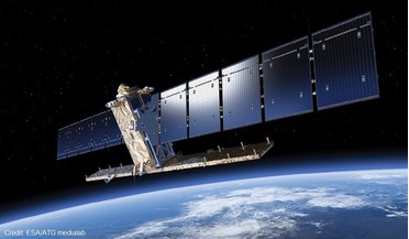
 October 2017
Colouring our view of the oceans
October 2017
Colouring our view of the oceans
...Earth and most of the oxygen we breathe. This stunning image was obtained by OLCI on 20 July 2016 and shows ... free and open basis in an integrated marine data stream incorporating data from its own polar-orbiting Metop satellites and geostationary...
 March 2019
International collaboration spawns scalable CubeSat EO payloads
March 2019
International collaboration spawns scalable CubeSat EO payloads
.... The use of a high-speed payload datalink and S-band downlink allow the user to receive more image data on ground - either expressed in coverage, or in the spectral information that can be captured (e.g. hyperspectral imagery). Typical applications...
 October 2015
Copernicus, ESA’s most ambitious Earth Observation programme
October 2015
Copernicus, ESA’s most ambitious Earth Observation programme
...is to deliver operational weather and climate-related satellite data, images, and products to the European National Meteorological Services ... the Earth in 12 spectral channels and provide image data that are core to operational forecasting needs, and...
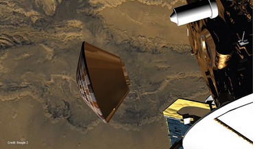 June 2015
Beagle 2: discovering the lost Mars lander
June 2015
Beagle 2: discovering the lost Mars lander
...to deploy successfully. Beagle 2’s components on Mars. A close-up, sharpened image of Beagle 2 Lander Target produced from two co-aligned HiRISE images. An overlay of Beagle 2’s outline on the image data. This is one possible scenario for the partial...
 March 2018
Shifting lines and new horizons in Earth observation markets
March 2018
Shifting lines and new horizons in Earth observation markets
... midstream and downstream layers. Depending on the weight of image data compared to other data (data-agnostic services), there may be opportunities for EO data owners or satellite operators, EO data brokers or for pure service players. EO development...
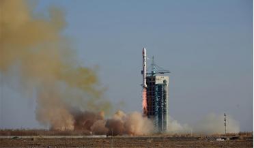 October 2023
Remote sensing by satellite - People’s Republic of China
October 2023
Remote sensing by satellite - People’s Republic of China
... from a 630 km-high SSO, the satellite is able to capture images of the Earth with a spatial resolution of about 1.5 m. The satellite has an X-band data link for sending image data to dedicated ground stations. A total of six missions have been...