 May 2020
Iran - emerging space state or threat to world peace?
May 2020
Iran - emerging space state or threat to world peace?
... Iranian President Ahmadinejad later stated that the launch had failed. In fact, Iran had already launched a satellite (Sina-1) using a Russian vehicle launched from Plesetsk on 27 October 2005. Much of Iran’s development of ballistic missiles and...
 January 2021
Time to change our relationship with space?
January 2021
Time to change our relationship with space?
...– inspiration. These are not compelling arguments to put before rational government treasuries and so the wider benefits of satellites are then appropriated as part of the rationale – benefits that can no longer be traced (if they ever were) to human...
 October 2018
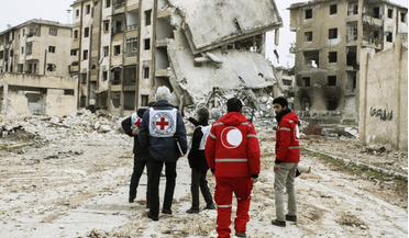
Using space-based data for humanitarian causes
October 2018
Using space-based data for humanitarian causes
...its offer of assistance, or remove itself from any such voluntary organisation, even though it is not as easy as it sounds. Satellite image of refugee camp at the Syrian-Jordanian border taken by UrtheCast’s Deimos-2. Protected data The real question...
 March 2021
Eyes on the prize
March 2021
Eyes on the prize
...realise it, the UK is in the premier league of world space technology, from instrumentation, data science and satellite operations to satellite manufacture. Government decisions over the past two decades, combined with a strong engineering base, mean...
 April 2021
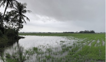
Predicting dengue fever outbreaks from space
April 2021
Predicting dengue fever outbreaks from space
... of the spatial variation of meteorological parameters, which may vary significantly at the local scale. Many high-quality satellite EO data products are available for free and systematic collection, which also enables scalability of the solution...
 October 2024
EO data - the fuel that makes climate action possible
October 2024
EO data - the fuel that makes climate action possible
...seven percent are inspected for leaks. AI & multi-satellite imaging This data is also crucial for financial institutions...applying advanced algorithms to images from a wide range of satellite imagery for any given area of interest, the precise location...