 16 February 2026
New tool could reduce collision risk for EO satellites
16 February 2026
New tool could reduce collision risk for EO satellites
...the orbital environment.” Many applications that support the SDGs rely on very high-resolution satellite imagery. To achieve this level of detail, satellites often operate at lower altitudes, which reduces their field of view. Alternatively, they can...
 March 2015
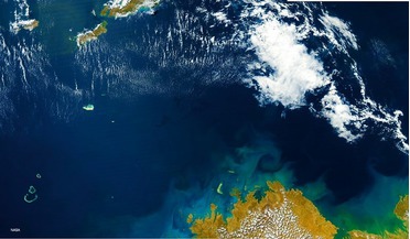
Shipping, the environment and satellite AIS
March 2015
Shipping, the environment and satellite AIS
... Gulf of Mexico following the Deepwater Horizon oil spill and the passage of Tropical Storm Bonnie in 2010. Satellite imagery can be used to study the impact of tropical storms on an environment affected by oil spills/maritime disaster With more...
 July 2014
A revitalised space sector reduces costs and makes space data more accessible
July 2014
A revitalised space sector reduces costs and makes space data more accessible
... to the businesses that will ultimately benefit from the use of these constellations. Making space data accessible Satellite imagery of the Earth is becoming ever more sophisticated. A wide variety of data are now available in a range of spatial...
 July 2014
Achilles’ heel
July 2014
Achilles’ heel
... infrastructure, leading to sustainable and rapid growth in these emerging markets. The armed forces have long used satellite imagery, communications and GNSS. Today, the demand for space services is expanding exponentially, with many nations relying...
 August 2016
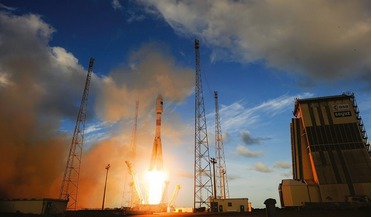
Smallsat launch strategy
August 2016
Smallsat launch strategy
... system as a whole remained intact. We would never have been able to mature the technology, grow our expertise in satellite manufacturing and operations, and expand our operational on-orbit fleet so quickly and effectively if we had simply manifested...
 September 2020
High hopes for Brazil’s space ambitions
September 2020
High hopes for Brazil’s space ambitions
...technologies to track their fleets; mining and resource industries use satellite imagery for exploration, to plan infrastructure, and to conduct impact studies; and satellite communications play a key role in enabling improved connectivity for remote...