 March 2015
Shipping, the environment and satellite AIS
March 2015
Shipping, the environment and satellite AIS
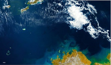
..., it can prove instrumental in helping to develop better planning, monitoring and navigation strategies for the future. Satellite AIS data lends itself to the creation of shipping density maps, an effective tool in the study of trends within the...
 January 2021
Time to change our relationship with space?
January 2021
Time to change our relationship with space?
... Europeans and the UN who freely share their satellite data in support of humanitarian natural disasters like flooding,...The Disasters Charter is a worldwide collaboration through which satellite data are made available for the benefit of disaster ...
 March 2021
Space weather and risk mitigation
March 2021
Space weather and risk mitigation
..., terrestrial infrastructure properties and exposure, as depicted in Fig. 2. In this sense, the availability of various satellite data - whenever needed - is a key to success. Figure 1. Statistics of power outages in the US in the period 1984...
 April 2021
Space industry trends in the pandemic
April 2021
Space industry trends in the pandemic
... 2021 and expects to complete construction of its own space station by 2022. New US administration The trend of using satellite data and analytics to independently monitor and manage the risk of climate change will accelerate in the coming year...
 October 2021
Technology transfer and the ‘local’ space market
October 2021
Technology transfer and the ‘local’ space market
... sector. Wildfires in California, USA, captured by Sentinel-2 in August 2020. Glasgow-based Omanos Analytics uses satellite data to support sustainable development, identifying and monitoring social and environmental impacts in order to reduce risk...
 May 2022
The Space Industry in 2022
May 2022
The Space Industry in 2022
... to Pad 39B at Kennedy Space Center prior to its first test flight. Ordinary people are now seeing satellite data typically reserved for spy agencies and getting insights into the on-going crisis as they never have...